Tu San canyon and Nho Que river as viewed from the Ma Pi Leng pass. The three landscapes create the most majestic scenery in Vietnam, considered the highlight along the panorama of the Dong Van stone plateau.
Previously, people could only see the Nho Que River from the pass and many desired to reach the turquoise water below. However, boats carrying visitors to Tu San canyon have been put into operation in the past year.
As a tributary of the Gam River, Nho Que River originates from Yunnan Province (China) with an altitude of 1,500m. The river enters Vietnamese territory in Xeo Lung village, behind the Lung Cu flagpole, and winds like a silk ribbon through the Tu San canyon below the Ma Pi Leng pass. It continues to flow through Meo Vac District to the Cao Bang Province and then merges into Gam river.
The 46km river runs through the Dong Van Karst Plateau Global Geopark to “meet” Tu San canyon, creating a picturesque aquarelle. Nho Que river has always had an emerald green colour, so it stands out amidst the grandiose scenery.
Considered as a unique tectonic canyon, Tu San is the deepest canyon in the Southeast Asia with a depth of between 7-900 metres and a length of up to 1.7 kilometres.
Geological tectonics over millions of years created Tu San, an item of special geological heritage.
Tu San canyon belongs to our geomorphic tectonic, paleontological and stratigraphic heritage. It is located in the Pa Vi, Pai Lung and Xin Cai Communes in the Meo Vac District.
Tu San canyon is located between two huge ravines and harmoniously combines with the emerald green Nho Que river, creating a majestic, poetic image.
There are two paths to the berth on Nho Que river, coming from Dong Van and Meo Vac. From Meo Vac, you have to go to the foot of Ma Pi Leng pass, turn right after about 5 kilometres in the direction of Xin Cai Commune, and then trek more than 2 kilometres. Meanwhile, from Dong Van, you can also go along the road to Ma Pi Leng for about 4 kilometres and then turn left at the junction with the pine hills after which you will see the sign to the Ta Lang berth.
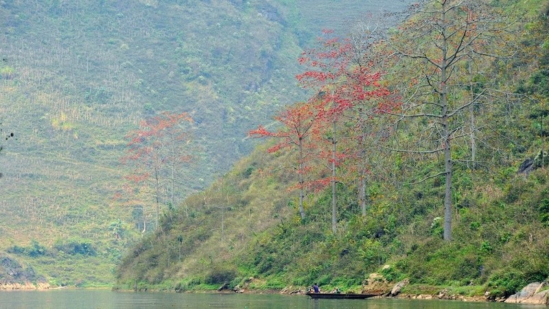
Blooms of flowers right near the Nho Que River hydroelectric dam, very close to the berth from Meo Vac.
Bombax flowers bloom most in the Quan Ba, Yen Minh and Dong Van Districts, and are scattered all the way to the Lung Cu flagpole…
... but the rows of bombax flowers along the valley below Tu San canyon next to the Nho Que river are considered the most beautiful.
Visiting the Nho Que river in the spring and watching the majestic sky and land encapsulated in the canyon are an unforgettable experience for visitors to Ha Giang Province.