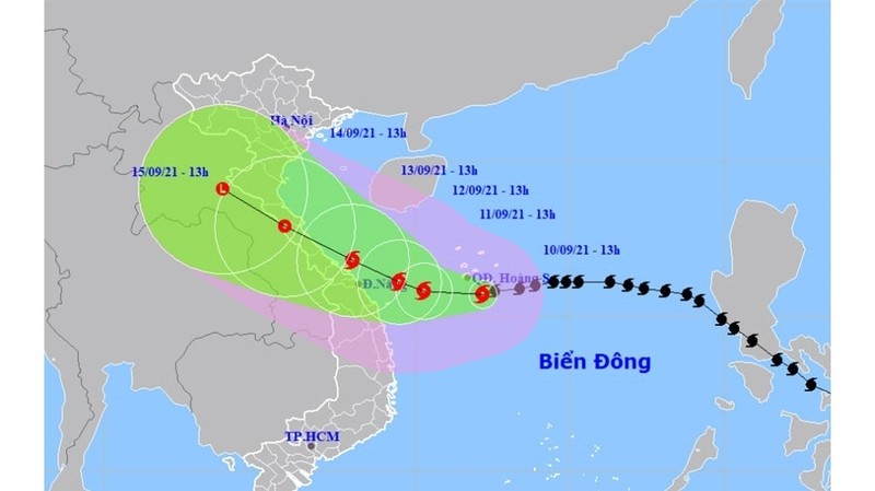
For the next 24 hours, the storm will move westward at a speed of 10 kilometres per hour and is likely to grow stronger. By 1pm on September 11, the location of storm No.5, internationally known as Conson will be around 15.8 degrees north latitude and 110.3 degrees east longitude, about 230 km east of the coast of Quang Tri-Quang Nam, packing 100-120 kilometres per hour winds (level 11), with shock at level 13.
The danger zone in the East Sea/South China Sea in the next 24 hours will be 18.5 degrees north latitude and 114 degrees east longitude.
Over the next 24-48 hours, the storm will move slowly west-northwest, at a speed of 5 kilometres per hour. By 1pm on September 12, the storm’s centre will be about 16.1 degrees north latitude and 109.5 east longitude, about 130 km east of the coast of Quang Tri-Quang Nam, with strongest winds near the centre at level 10-11 (90-115 kilometres per hour), shock at level 13.
For the following 48-72 hours, the storm will move west-northwest, at a speed of 5-10 kilometres per hour. By 1pm on September 13, the storm’s centre will be about 16.8 degrees north latitude and 108.0 east longitude, right on the waters from Quang Tri to Quang Ngai, with strongest winds near the centre at level 9 (75-90 kilometres per hour), with shock at level 11.
In the next 72 to 120 hours, the storm will move northwestwards, at a speed of 10 kilometres per hour, directly affecting the mainland from Thanh Hoa to Quang Ngai.


