>>> Storm Cempaka moves northwestward, towards China
This afternoon, Head of the Weather Forecasting Department under the National Centre for Hydro-Meteorological Forecasting (NCHMF) Tran Quang Nang said that it is likely that on July 22-23, the storm, the third of its kind to hit the East Sea, will enter the Gulf of Tonkin and cause heavy rain in some localities in the Northeast, such as Lang Son, Hai Phong, and Quang Ninh.
In particular, Co To and Bach Long Vi islands need to be aware of the possibility of heavy rains combined with strong winds during the circulation of the storms.
Nang said the storm is complicated and has continuously changed its direction. On the other hand, there is also a new storm with the international name Infa approaching the East Sea, about 850km from Taiwan (China), which could interact with and affect the motion trajectory of storm No. 3.
Alongside this, due to the influence of a low pressure trench with its axis passing through the North and connecting with storm No. 3, heavy rains are expected in the Northwest from tonight with common rainfall of 20-40mm per 24 hours, even up to and over 60mm/24h.
In the Northeast and North Central areas, there will be scattered showers and thunderstorms, with moderate and heavy rain concentrated this evening and tonight. There is also a risk of flash floods, landslides and local flooding in mountainous provinces.
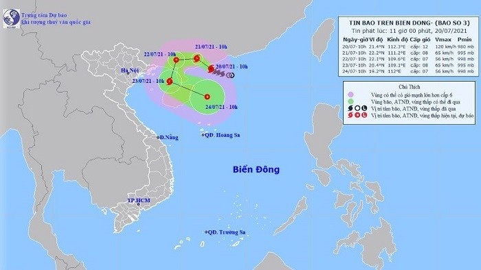
According to a bulletin from the NCHMF, at 10 am today, the location of the storm was the southern sea of Guangdong province (China), packing strongest winds of 100-135km/h.
The storm is forecast to move in a northwest direction, at about 5km per hour. At 10 o'clock on July 21, the centre of the storm will be on the mainland, southwest of Guangdong province (China), with strongest winds of 60-75km/h.
From 10 am on July 21 to 10 on July 22, the storm is likely to change direction and move mainly to the west, traveling at 5-10km per hour and thereafter weakening into a tropical depression.
Meteorologists are advising fishermen and crew members operating at sea to regularly monitor weather forecasts and observe the sky and sea surface, guiding their ships to come ashore or stay away from the affected areas of storms and tropical depressions if necessary.
People in mountainous regions are warned to be alert for signs of flash floods and quickly move away from areas affected, as well as being ready to evacuate according to the instructions of the concerned authorities.


