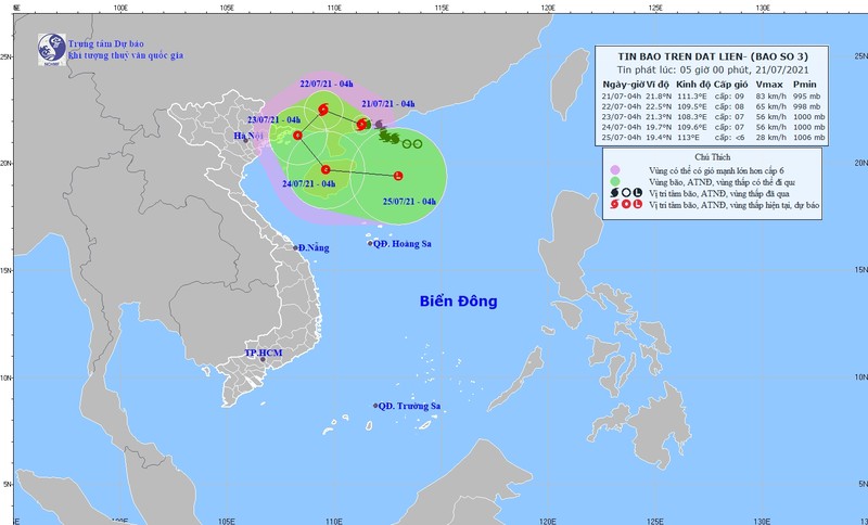
At 4am on July 21, the centre of the storm was at about 21.8 degrees north latitude and 111.3 degrees right on the mainland south of Guangdong Province (China), packing winds of 75-90 kilometres per hour (level 11), with shock at level 11.
For the next 24 hours, the storm will move north-westwards at a speed of 5-10 kilometres per hour. The danger zone in the East Sea (South China Sea) in the next 24 hours will be at 20.0 degrees north latitude and 108.0-113.0 degrees east longitude.
Over the following 24-48 hours, the storm is likely to change direction and move south-westwards at a speed of 5-10 kilometres per hour, gradually weakening into a tropical depression.
It is forecast that due to the influence of the tropical convergence band with the axis passing through the North connecting with Storm Cempaka, there will be scattered showers and thunderstorms in the Northern region and Thanh Hoa on July 21, with moderate and heavy rain locally with average rainfall of 20-40mm/24 hours, even more than 60mm/24 hours in some places.
Due to the influence of the tropical convergence band combined with the western edge of Storm Cempaka, from July 22-24, in the North and North Central regions, there will be moderate rain and heavy rain with a common rainfall of 50-100mm, even over 250mm in some places.
The Northern region and Thanh Hoa Province continue to be warned of thunderstorms from July 21-24, with moderate to heavy rains locally and risks of flash floods and landslides in mountainous provinces.


