The strongest wind in the area near the centre of the storm was at level 10-11 (90-120 kilometres per hour, with shock at level 13.
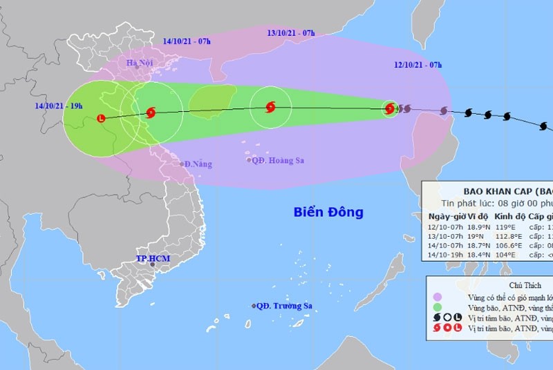
As of 7am on October 13, the storm’s centre is projected to be 19.0 degrees north latitude and 112.8 degrees east longitude, about 320 kilometres to the north-northeast of Hoang Sa. The strongest winds in the area near the centre of storm are expected to be about 100-120 kilometres per hour (level 11), with shock at level 14.
Dangerous areas in the East Sea in the next 24 hours will be 16.0-22.0 degrees north latitude; 110.5 degrees degrees east longitude. All vessels operating in the danger zone are at high risk of being affected by strong winds, high waves and tornadoes.
In the next 24 to 48 hours, the storm will move rapidly mainly to the west, traveling 25-30 kilometres per hour, and is likely to gradually weaken in intensity.
By 7 am on October 14, the storm’s centre is projected to be 18.7 degrees north latitude and 106.6 degrees east longitude on the waters off the shores from Thanh Hoa Province to Quang Binh Province. The strongest winds near its eye will be 60-75 kilometres per hour, with shock at level 10.
The danger zone on the East Sea in the next 24-48 hours will be at 15.5 degrees north latitude, 116.0 degrees east longitude. All vessels operating in the danger zone are at high risk of being affected by strong winds, high waves and tornadoes.
48 to 60 hours from now, the storm will travel west-southwest at about 20 kilometres per hour inland and weaken into a tropical depression, then a low pressure area over Central Laos.
* It is forecast that due to the influence of the tropical convergence zone with an axis of about 16-19 degrees north latitude combined with the strong southwest monsoon, from October 12-13, the Central Highlands and the South will face heavy rain and thunderstorms, even very heavy rain in some places (the heavy rain will be concentrated in the afternoon and evening).


