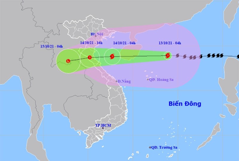
For the next 24 hours, the storm will move west at a speed of 25-30 kilometres per hour and is likely to gradually weaken in intensity.
By 4am on October 14, the location of storm will be around 18.8 degrees north latitude and 107.7 degrees east longitude, packing 75-90 kilometres per hour winds (level 11).
The danger zone in the East Sea in the next 24 hours will be 16.0 degrees north latitude and 117.0 degrees east longitude. All vessels operating in the danger zone are at high risk of being affected by strong winds, high waves and tornadoes.
In the next 24-36 hours, the storm will move mainly westward, at a speed of 20 kilometres per hour, travel inland from Thanh Hoa to Quang Binh provinces and weaken into a tropical depression.
By 4pm on October 14, the location of the tropical depression will be around 18.7 degrees north latitude and 105.2 degrees east longitude. The strongest winds in the area near the centre of depression are expected to be about 40-50 kilometres per hour (level 6), with shock at level 8.
36 to 48 hours from now, the tropical depression will travel west at about 20 kilometres per hour inland and weaken into a low pressure area over Central Laos.
The danger zone on the East Sea in the next 24-48 hours will be at 15.5 degrees north latitude, 111.0 degrees east longitude. All vessels operating in the danger zone are at high risk of being affected by strong winds, high waves and tornadoes.


