According to the National Centre for Hydro - Meteorological Forecasting (NCHMF), due to the impact of the circulation from storm Mangkhut, the sixth to hit Vietnam’s East Sea this year, heavy rains from 100-150mm are likely to focus on localities in the Viet Bac area.
High risk of flash floods and landslides have been warned in the northern mountainous provinces, including Quang Ninh, Lang Son, Cao Bang, Bac Can, Ha Giang, Lao Cai and Yen Bai.
Several islands in the Gulf of Tonkin, including Bach Long Vi and Co To, have suffered from strong winds as a result of Mangkhut.
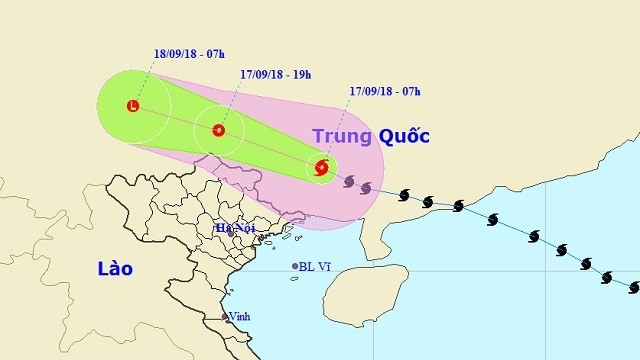
At 7 am on Monday morning, the hurricane’s location was at about 23.0 degrees north latitude and 108.5 degrees East longitude, on the southern mainland of China’s Guangxi province, about 220 km north of Vietnam’s northeastern border. The strongest wind near its centre reached 60-75 km/h.
It is forecast that, in the next 12 hours, the typhoon will move northwestward, traveling 25-30 km/h deep into the mainland and weakening into a tropical depression. In the next 12-24 hours, the tropical depression will move west-northwest at a speed of 25 km/h and weaken into a low-pressure zone.
By 7 am on September 18, the centre of the low-pressure area will be at about 24.8 degrees north latitude and 103.0 degrees east longitude, on the southern mainland of Guangxi (China), with the strongest wind dropping to below 40 km/h.
 |
Tra Ly Border Station’s soldiers in Thai Binh province instruct fishermen to seek shelter against Mangkhut. (Photo: NDO/Lai Hop Khanh)
Northern and north-central localities have taken measures to prepare themselves for the super typhoon, which has caused severe damage to the countries on its path in recent days.
Localities across northern Vietnam have been ready to evacuate locals in risky areas, especially in coastal and river mouth areas, while ensuring safety for dykes and works under construction.
 |
Deputy PM Trinh Dinh Dung (second from right) inspects Ha Nam dike in Quang Yen town, Quang Ninh province, on September 16. (Photo: NDO/Quang Tho)
On early September 16, Deputy Prime Minister Trinh Dinh Dung inspected preparations for Typhoon Mangkhut in the northern coastal province of Quang Ninh. He visited the Ha Nam dyke system and Yen Lap lake in Quang Yen town.
Localities along the coastline had called all vessels ashore and locals in aquatic farms and beaches were to return home by the afternoon of September 16. Dykes and public buildings had also been reinforced, while locals have been provided with guidance on necessary measures to prepare for the storm.


