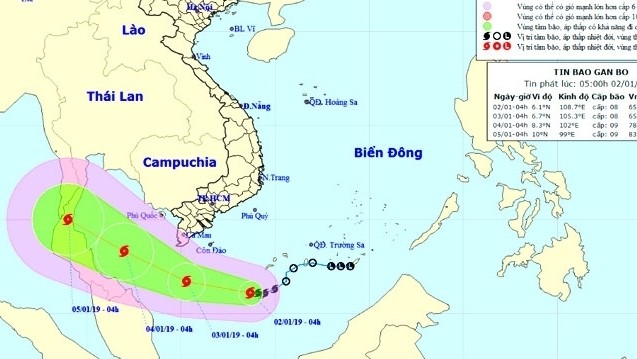
The latest report from the national weather service showed that as of 7 am this morning, the storm, internationally named Pabuk, was about 460 km to the southeast of the mainland in the South, about 360 km southeast of Con Dao Island. The strongest wind near its centre is from 60 to 75 km/h.
It is forecast to move in the west-northwest direction at a speed of 15 km/h in the next three days and is likely to be stronger, with winds blowing 75-90 km/h.
Strong winds and rough seas are expected in the southern part of the East Sea, as well as waters off the provinces from Quang Ngai to Binh Thuan (including Phu Quy island district) and localities from Ba Ria-Vung Tau to Ca Mau (including Con Dao island district).
To cope with the upcoming storm, on January 1 the Central Steering Committee for Natural Disaster Prevention and Control sent an urgent telegraph to its local members, urging for coastal provinces and cities from Quang Ngai to Ca Mau and Kien Giang, as well as related ministries and units, to notify vessels operating at sea on the location and direction of the storm to escape from dangerous areas.
The committee also requested for the control of vessels going out to sea, while keeping regular communication with ship owners to promptly handle possible bad situations, instructing vessels to anchor on islands and being ready for search and rescue work.
Meanwhile, over the past three days, provinces from Ha Tinh to Phu Yen have suffered from heavy rains. It is forecast that, due to the influence of cold air combined with east winds, provinces from Thua Thien - Hue to Binh Thuan will witness heavy rains with average rainfalls from 70 to 150 mm, even 200 mm. Heavy rains are likely to last until January 4.
The storm circulation is also forecast to bring heavy rains up to 200 mm to the Southwest, as well as a high possibility of thunderstorms and tornadoes in the region.
 |
Frost is seen at Mau Son tourist area in Lang Son province due to prolonged cold in recent days. (Photo: NDO/Hung Trang)
In the North and North Central Vietnam, the current strength of cold air has caused extreme cold, with some locales suffering from temperatures having plunged to minus Celsius, such as -0.6C in Mau Son (Lang Son province), 3.5C in tourist town of Sapa, 4.1C in Tam Dao (Vinh Phuc), 3.5C in Trung Khanh (Cao Bang) and 10C in Hanoi.
It is forecast that strong cold air will continue to cause widespread damaging cold in the North with the lowest temperatures ranging from 8 to 11C, even from 4 to 7C in mountainous areas. The damaging cold is likely to last until January 4.
 |
 |
 |
Frost is seen at Mau Son tourist area in Lang Son province due to prolonged cold in recent days. (Photo: NDO/Hung Trang)


