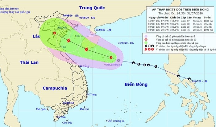
As of 1pm on July 31, the depression’s centre was at about 17.2 degrees north latitude and 112.5 degrees east longitude, right in the waters of the Hoang Sa (Paracel) Archipelago, packing winds of 40-60 kilometres per hour (level 6-7), shock at level 9.
For the next 24 hours, the low depression will move west-northwestwards at 10-15 kilometres per hour and could gain further vigour to become a storm. By 1pm on August 1, the centre of the storm will be at about 18.3 degrees north latitude and 109.2 degrees east longitude, with the strongest winds near the centre at level 8 (60-75 kilometres per hour), shock at level 10.
The danger zone in the East Sea in the next 24 hours will be 15 degrees north latitude and 107 degrees east longitude.
In the next 24-48 hours, the storm will move west-northwestwards at speeds of 10-15 kilometres per hour. By 1pm on August 2, the storm’s centre will be about 19.5 degrees north latitude and 106.8 east longitude in the Gulf of Tonkin, 120 kilometres east-southeast of the coast of provinces from Thai Binh to Nghe An. The strongest winds near the storm’s centre will be 60-75 kilometres per hour (level 8), shock at level 10.
For the following 48-72 hours, the storm will keep moving west-northwestwards at a speed of 10 kilometres per hour, heading into the northern and north central provinces with a disaster risk at level 3.
The tropical depression is forecast to cause heavy rains, strong winds, high waves of two to five metres and rough conditions in the East Sea.


