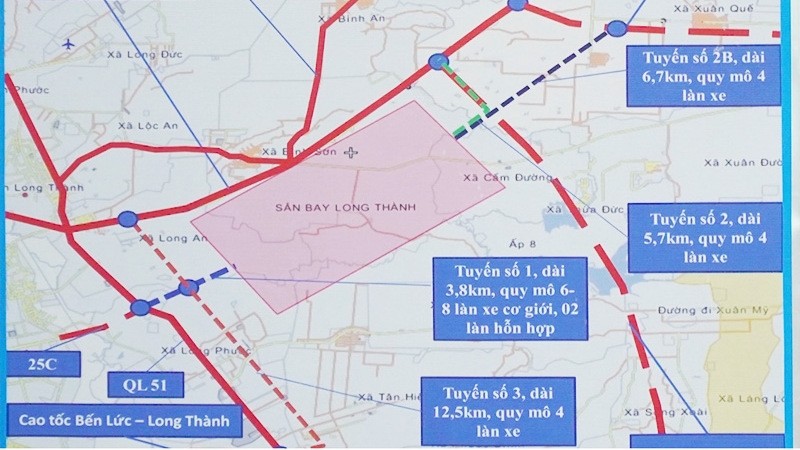
Route 1 will be 3.8 kilometres long, with ten lanes, and connect the main axis of the airport with the Bien Hoa-Vung Tau Expressway, National Highway 51 and provincial road 25C.
Route 2 will link Route 1 to the Ho Chi Minh City-Long Thanh-Dau Giay Expressway, with four lanes and a length of 3.5 kilometres.
Route 3 will run 8.5 kilometres and connects the eastern end of the main airport axis with the Phan Thiet-Dau Giay Expressway while Route 4 is to link Route 3 with the Ho Chi Minh City-Long Thanh-Dau Giay Expressway at a length of 3 kilometres.
Both Route 3 and Route 4 will both have eight lanes.
Currently the Dong Nai provincial authorities are working with the Airports Corporation of Vietnam (ACV) to implement site clearance for the construction of Route 1 and 2 to serve the transport of building materials for the first phase of Long Thanh Airport.
At the same time, Dong Nai Province is also working to clear the remaining land to be transferred to the ACV in June, and to complete the infrastructure of the Loc An-Binh Son resettlement zone.
Long Thanh Airport is being built on an area of 5,000 hectares in Long Thanh District of Dong Nai Province to serve Ho Chi Minh City, replacing the currently overburdened Tan Son Nhat Airport.
The first phase of the new airport is scheduled for completion in 2025, featuring a 4,000-metre-long runway and a passenger terminal with an annual capacity of 25 million passengers.
The total cost for the first phase is estimated at VND109 trillion (US$4.7 billion).


