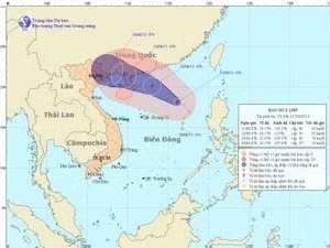
The storm was about 350 km northeast of the Hoang Sa (Paracel) archipelago at 7 pm on June 21, with wind speeds in the storm's eye reaching 62-88 km per hour.
It is forecast to move between northwest and west northwest, at about 15-20 km per hour and approach the Quang Ninh-Hai Phong coastal line during the afternoon of June 22.
A storm warning has been issued to 41,300 offshore fishing vessels, informing them of the storm's progress and urging them to make appropriate preparations, following an order from the National Steering Committee for Flood and Storm Prevention and Control.
Authorised provincial and municipal agencies are asked to instruct offshore boats to take shelter before the weekend, especially those in the Tonkin Gulf and the northern part of the Hoang Sa Archipelago.
The storm is also expected to produce rough seas in the northern part of the East Sea.
It is predicted that coastal areas from central Binh Thuan province to southern Ca Mau province will also experience strong winds and rough waters.
Deputy Director of the National Centre for Hydro-Meteorology Forecasting, Le Thanh Hai, said that the storm will bring heavy rains to northern provinces and cities on June 23.
Hai also added that the central provinces of Ha Tinh, Nghe An and Thanh Hoa should prepare for landslides and flash floods on the same day.


![[Video] Viet Nam sends over 53,100 workers abroad in five months](https://en-cdn.nhandan.vn/images/8f440db7b9bfe62cb5397a6750a8b01b0dbbf7559b6b2d75a49d9659e594c458401c899a06eb5a6ef51d633ce7774de3e9025c2d7944d75148de8ee1664be9e4/6-5-video.jpg.avif)