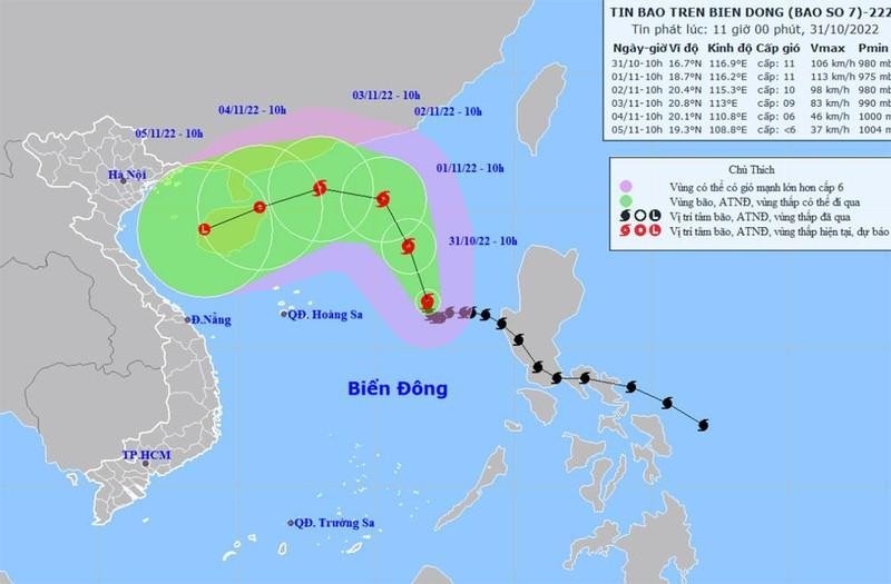
It is forecast that in the next 24 hours, the storm will likely grow stronger.
By 10 am on November 1, the typhoon will be about 18.7 degrees north latitude and 116.2 degrees east longitude, about 550km from Hoang Sa archipelago to the east-northeast.The strongest winds near the centre will be at level 11, with shock at level 13.
By 10 am on November 2, the typhoon will be about 20.4 degrees north latitude and 115.3 degrees east longitude, about 570km from the Hoang Sa archipelago to the northeast. The strongest winds near the centre will be at level 10-11, with shock at level 13.
Over the next 48-72 hours, the storm is likely to change direction and move to the west-northwest, at a speed of 10 kilometres per hour. The strongest winds near the centre will be at level 8-9, with shock at level 11.
72 to 96 hours from now, the storm will move mainly to the west-southwest, at a speed of 10 kilometres per hour, and gradually weaken into a tropical depression.
From the next 96 to 120 hours, the tropical depression moves mainly southwest, at a speed of 10 kilometres per hour, and gradually weakens into a low-pressure area.
Due to the influence of storm No. 7, the east coast of the northern and central areas of the East Sea (including the waters of the Paracel Islands) will experience strong winds of levels 8-9, the strongest winds near the centre will be at level 10-11, with shock at level 13.


