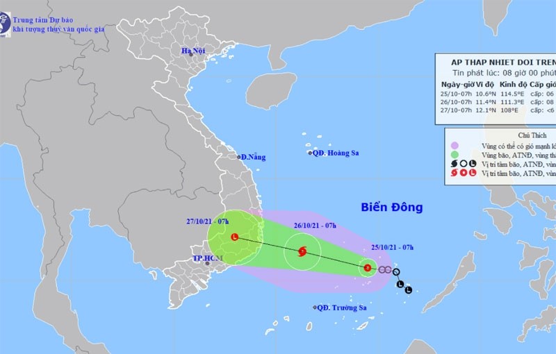
At 7am on October 25, the centre of the tropical depression was at about 10.6 degrees north latitude and 114.5 degrees east longitude, about 110 kilometres to the south-east of Song Tu Tay Island (within Vietnam’s Spratly Archipelago), with the strongest winds near its centre blowing at 40-50 kilometres per hour) and shock at level 8.
It is forecast that in the next 24 hours, the tropical depression will move mainly to the northwest, at a speed of about 15 kilometres per hour, and is likely to strengthen into a storm.
At 7am on October 26, the centre of the tropical depression was at about 11.4 degrees north latitude and 111.3 degrees east longitude, about 230 km east offshore of the provinces from Binh Dinh to Binh Thuan. The strongest winds in the area near the centre of the storm were at level 8 (60-75 kilometres per hour), with shock at level 10.
Dangerous areas in the East Sea/South China Sea in the next 24 hours will be at 9.0-13.0 degrees north latitude; 110-115.5 degrees east longitude. All vessels operating in the danger zone are at high risk of being affected by strong winds, high waves and tornadoes.
In the next 24 to 48 hours, the storm will move rapidly in a mainly west-northwest direction, travelling at about 15 kilometres per hour, and is likely to gradually weaken into a tropical depression entering the area from Binh Dinh to Binh Thuan, then a low-pressure area over the southern area of the Central Highlands.


