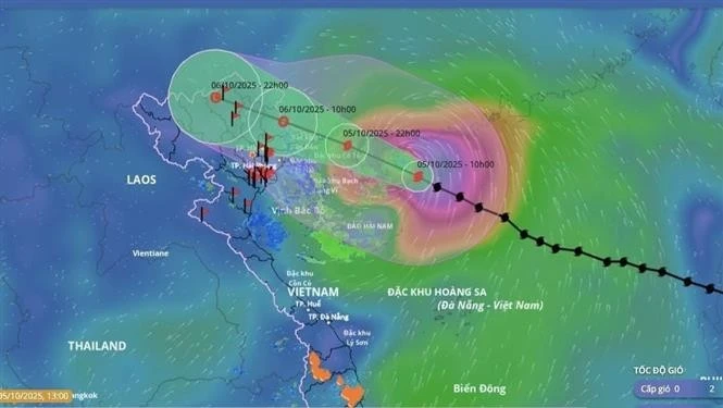
At 10 pm on October 5, the storm is expected to be located over the sea area off Quang Ninh with winds at level 11–12, gusting up to level 15, moving west-northwest at a speed of 20–25 km per hour. Affected areas include the north-western part of the northern East Sea, the northern Gulf of Tonkin, and coastal areas from Quang Ninh to Hung Yen and Lang Son provinces. The disaster risk level is assessed at level 3.
By 10 am on October 6, the typhoon is forecast to reach the border area between Lang Son (Viet Nam) and Guangxi (China), with winds of level 6–7, gusting to level 9, continuing west-northwest at about 20 km per hour. The affected areas remain the northern Gulf of Tonkin and coastal provinces from Quang Ninh to Hung Yen, including Lang Son. The disaster risk level remains at level 3.
By 10 pm on October 6, the storm will have weakened into a tropical depression over the northern mountainous region, with winds below level 6, moving west-northwest at around 20 km per hour.
Due to the impact of the typhoon, the north-western waters of the northern East Sea will experience strong winds at levels 8–10, increasing to 11–13 near the storm’s centre, with gusts up to level 15–16. Wave heights are forecast at 4–6m, reaching 6–8m near the eye of the storm, causing extremely rough seas with destructive potential capable of sinking large vessels.
Coastal and island areas of Quang Ninh and Hai Phong provinces will see storm surges of 0.4–0.6 m. Low-lying coastal and estuarine areas are advised to take precautions against flooding and high waves from the afternoon and evening of October 5.
Weather conditions at sea and in coastal areas during the storm will be extremely hazardous, unsafe for all vessels and structures within the affected zones. Strong winds, large waves and storm surges could overturn or destroy boats and cause coastal flooding.
From the night of October 5 to the night of October 7, heavy to very heavy rainfall is forecast across the northern midland and mountainous regions, with common rainfall of 150–250mm and isolated areas exceeding 400mm.
The northern delta and Thanh Hoa provinces are expected to see moderate to heavy rain, ranging from 70–150mm, with localised downpours above 200mm. Rainfall intensity may exceed 150mm within three hours in some areas.
Total rainfall between October 5 and 7 is projected at 150–250mm in the northern mountainous and midland regions, with some areas surpassing 400mm, while the northern delta and Thanh Hoa may record 70–150mm, locally above 200mm.
Heavy rains could cause flooding in low-lying and urban areas, flash floods in small rivers and streams, and landslides on steep slopes.
The NCHMF also warned of potential flooding on rivers in the northern region and Thanh Hoa, with disaster risk at level 2.
According to the Civil Aviation Authority of Viet Nam (CAAV), airports forecast to be directly affected include Van Don International Airport in Quang Ninh province and Cat Bi Airport in Hai Phong City. Meanwhile, Noi Bai International Airport in Hanoi, as well as Tho Xuan, Vinh and Dien Bien airports in Thanh Hoa, Nghe An and Dien Bien provinces, respectively, have been advised to stay updated and prepared for any abnormal developments of the storm.


