In the context of increasingly unpredictable impacts of climate change, whereby natural disasters no longer follow the rules, the field of irrigation, natural disaster prevention and control needs a flexible management model, quick adaptation, and timely decision making based on digitised data to respond more effectively to limit damage to people and property.
Digital transformation in the field of irrigation, natural disaster prevention and control helps improve the capacity for forecasting, early warning, response to drought, water shortage, saltwater intrusion, floods, inundation, and safe and effective operation of irrigation works.
Timely decision-making helps mitigate natural disasters
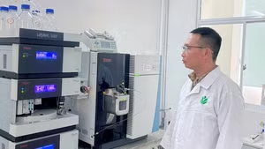
In recent years, drought, water shortage, and saltwater intrusion have occurred frequently across the country. Therefore, the Department of Irrigation Works Management and Construction has applied digital technology to quickly, promptly, and accurately update information of hundreds of thousands of irrigation works, with millions of different data points, based on a digital platform to serve effective direction, operation, and response. Specifically, a number of specialised information systems and software programmes have been built and are gradually providing effective support.
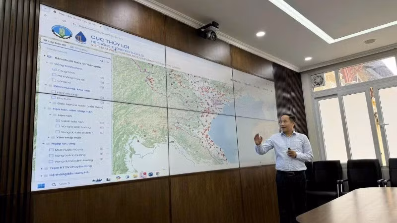
Referring to this issue, Director of the Department of Management and Construction of Irrigation Works Nguyen Tung Phong said 2020-2025 is a period of strong development of information systems and databases in the field of irrigation, typically the information system supporting the direction and operation of water supply for winter-spring crop production in the midlands and the Northern Delta. This is a very effective support tool in implementing water intake and regulation from hydroelectric reservoirs for annual rice cultivation; collecting water levels online at large irrigation works; collecting water areas per day; and providing periodic, regular and ad hoc supplies. This approach has brought great efficiency, supporting the shortening of the operation from three water discharges as before to two; and reducing the total water discharge of hydroelectric reservoirs from about 5 billion m3 to about 3 billion m3 in recent years.
In addition, information systems for operation and irrigation management, information systems Irrigation planning management, dam and reservoir database systems have also been effectively supporting the improvement of efficiency in directing and operating the prevention and control of drought, water shortages, and saltwater intrusion. For example, during the historic saltwater intrusion in the 2019-2020 dry season in the Mekong Delta, thanks to information and data, the Ministry of Agriculture and Environment made accurate and timely decisions to respond, so only 59,000 hectares of winter-spring rice were damaged, much lower than in 2015-2016 when the figure was 405,000 hectares.
In recent years, the promotion of digital transformation at Bac Hung Hai Irrigation Works Exploitation Company Limited has also helped improve management and operation efficiency, reduce labour and have quick and accurate information in operations.
Vu Huu Tuan, Head of the Operation Department, said: “Previously, the company's workers had to measure salinity, rainfall, and water level manually. A large number of workers were needed to ensure all necessary parameters, and there were sometimes errors when measuring.
“Therefore, the company has built a relatively complete SCADA system by installing 11 automatic rainfall measuring devices to provide flood forecasting and warning data; 22 water level measuring devices to monitor and provide timely management plans; three automatic salinity measuring stations; 20 surveillance cameras to detect incidents early and support remote management; build detailed digital maps of canal systems, works and irrigation and drainage areas on the Google Maps platform to manage, store, and access information about the works. SCADA tools and equipment not only help provide information about the works and provide effective plans for exploitation, operation, maintenance, and repair of the works at low costs. At the same time, they provide timely information on water levels, rainfall, salinity, etc., for reasonable management.”
Improving the technology infrastructure system
In recent times, with the effective support of digital transformation, the work of forecasting and early warning of natural disasters has become increasingly effective, helping ministries, departments, branches, and localities have sufficient information to direct, operate and minimise risks caused by natural disasters.
According to Tran Cong Tuyen, Head of the Dike Management Department (Department of Dike Management and Natural Disaster Prevention and Control): “Currently, we have implemented a WebGIS database on dikes in 21 localities with dikes of level III or higher. From there, we provide full information, images, and documents on dike routes, especially key vulnerable dike points. At the same time, the software to monitor water levels of rivers with dikes is built, accessed via the website and application on Android and iOS devices, providing information on actual water levels, alarm water levels, helping to grasp information fully, promptly, and effectively advise, especially when directing dike protection.
“In particular, there are 80 surveillance cameras at key vulnerable locations of dikes... monitoring and tracking the progress of works, real-time flood levels, thereby helping with proactive management, protection, and response. In addition, the use of flycams has supplemented the database, images of dike protection corridors, beaches, riverbeds, landslide and flooding locations due to large floods, timely response to flood prevention, control, and dike management.”
Also, since 2020, the department has utilised the Zalo platform to inform people about weather and natural disaster developments. After nearly 5 years of operation, more than 100 million messages are sent to disaster-affected areas across the country each year and the department now has hundreds of thousands of followers.

For the safe operation of irrigation works and effective response to natural disasters, data plays a key role, but the development of automatic data to date is still mainly scattered, unsynchronised, and unstandardised; many irrigation works have not yet collected automatic monitoring data and have not yet connected to real-time data; and simulation and warning models have not been equipped. Therefore, it directly affects the efficiency of water distribution, flood regulation, dam safety, and disaster response. In particular, the application of digital technology, data and operations in the network environment is still limited. On the other hand, there is a shortage of resources, the information technology infrastructure system, telecommunications, and hydrometeorological monitoring network are not synchronised, not meeting the requirements of digital transformation. The integration and sharing of data between systems also faces many difficulties.
Nguyen Manh Hung, Head of the Department of Operation Management and Irrigation (Department of Irrigation Construction and Management), said that in the coming time, the department will strive to complete the digital ecosystem of the irrigation sector; standardise and form a national database on irrigation; build and integrate digital twin models (Digital Twin) for large projects; apply artificial intelligence (AI) and machine learning (ML) in forecasting and operating smart reservoirs; integrate IoT monitoring data with digital maps and operating software; train specialised staff in digital technology, big data and modelling; and promote a change in thinking from manual operation to intelligent scenario operation.
Furthermore, it will apply simulation and forecasting models, integrate decision support systems, help build optimal operation plans, and reduce risks and waste; and combine remote sensing-GIS-AI technology in monitoring actual cultivation and planting areas, forecasting irrigation needs, detecting abnormalities in construction operations. AI technology also supports trend analysis, warning of safety risks and planning seasonal operations.
According to the Department of Dyke Management and Disaster Prevention, it is necessary to pay attention to and promote the completion of the database system, management system, and data exploitation to serve management work in the coming time.
In the long term, it is necessary to develop a decision support system applying new technologies such as: AI, big data, cloud storage; promoting the construction of a synchronous monitoring network of the dike system, riverbank management; Increase the application of new technologies in data collection such as high-resolution remote sensing images, flycam, and LiDAR technology to create 3D maps. Meanwhile, there should be an increase in training and fostering to improve the capacity of applying information technology and digital transformation of staff, especially in localities, to exploit and update databases, and improve the effectiveness of management and protection of dykes.