To bring the resolution into practice, the sector has accelerated the application of software and technological equipment — especially remote sensing technology — producing practical results.
Effectiveness from digital technology solutions
Viet Nam’s total forest area is currently over 14 million hectares, including more than 10 million hectares of natural forest, and the remainder being plantation forest. After administrative mergers, all 34 provinces and centrally run cities nationwide now have forest areas. With such a large forest area and limited human resources, applying technological solutions in forest management and protection has become a top priority for the forestry sector.
Identifying the importance of digital technology application, since 2000 the forestry sector has been proactively researching and applying remote sensing images with resolutions ranging from low to high from satellites such as NOAA, MODIS, LANDSAT, SENTINEL, SPOT5, and VNREDSAT-1. These efforts have helped improve the effectiveness and transparency of forest surveys and inventories. Specifically, from 2013 to 2016, during the nationwide forest inventory process, more than 720 high-resolution remote sensing images were used. As a result, forest status maps at a 1:10,000 scale were produced, and data for 7.1 million forest plots, including details on situations, reserves, and forest ownership, were established. Today, SPOT6/7 remote sensing images continue to be applied for forest inventory in the Central Highlands provinces and for forest surveys in other provinces. This is a “digital revolution” breakthrough for the sector, contributing to significantly changing traditional survey and inventory methods.
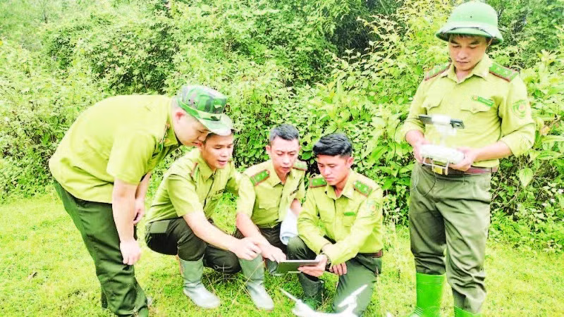
The year 2020 marked a major turning point for the sector’s digital transformation. During this period, the forestry sector successfully piloted the use of SENTINEL and LANDSAT satellite images to detect early forest changes. Previously, NOAA and TERRA satellite images were used to identify hot spots and areas with high wildfire risks. Apart from the remote sensing technology, the application of specialised software and technical devices has significantly supported forest inventory, wildfire detection, and forest owner management. In areas with rugged and hard-to-access terrain, technologies such as LIDAR and GPS have helped forest rangers accurately update forest status, develop forest maps, and preserve biodiversity.
In addition, technological solution applications have also helped forest rangers detect early and handle violations of the Forestry Law. For example, in Ha Giang Province (now Tuyen Quang), thanks to using FRMS, QGIS, and MAPINFO software in 2024, forest rangers detected four forestry violations, eight fewer than in 2023, with total fines amounting to 65 million VND. In Lao Cai Province, in the first six months of 2024, the application of GIS technology and remote sensing images helped detect and handle 86 forest-related violations.
According to Nguyen Huu Thien, Deputy Head of the Forestry and Forest Ranger Department under the Ministry of Agriculture and Environment, the implementation of the Politburo’s Resolution No. 57-NQ/TW has created strong momentum, laying the foundation for deep and broad digital transformation in the forestry sector. It has also had positive and comprehensive impacts on forest management, protection, and development. Forest management methods have clearly shifted from manual and traditional methods to modern ones. The application of digital technology, big data, and artificial intelligence (AI) has helped forestry officers improve their ability to monitor and analyse forest data and make timely, accurate decisions.
The standardisation and interconnection of databases with other sectors have increased transparency and efficiency in state management coordination. The organisational capacity and professional qualifications of forestry staff have gradually improved, therefore, forming a digital mindset and digital working methods suitable to the context of digital transformation. Particularly, the establishment of a policy framework has created favourable conditions for enterprises, research organisations, and domestic and international partners to invest in and transfer technology, contributing to the development of a sustainable, modern, and climate-change-adaptive forestry sector.
Difficulties and challenges
Apart from advantages and effectiveness of digital transformation, the forestry sector and forest rangers also faces difficulties such as: technological equipment for forest monitoring, including GPS, drones (DRONE), LIDAR devices, have not been invested fully and synchronously. Harsh weather and climate conditions in many forested areas affect the durability of machinery and equipment. High-quality remote sensing images from satellites have not been provided widely, creating difficulties for forest status analysis and assessment.
Funding for digital technology applications, especially remote sensing technology, remains insufficient and unstable. Investment in specialised software, database maintenance, as well as training for forest rangers still lacks synchronisation. Additionally, clarifying the authority, responsibilities, and coordination mechanisms between provincial and grassroots levels after July 1, 2025, when software systems and forestry data collection and usage are implemented, must be ensured consistently and effectively.
To overcome difficulties and continue enhancing digital technology solution application for forest management and protection, Nguyen Huu Thien said that based on the guidelines of Resolution No. 57-NQ/TW, the Forestry and Forest Ranger Department has advised the Ministry of Agricultural and Environment to focus on upgrading information technology infrastructure and equipment for digital transformation.
Priority will be given to servers, networks, and terminal devices across forest management units nationwide. In parallel with new investments, the department will continue deploying GIS application platforms, satellite images, drones, and AI in forest investigation, monitoring, and wildfire prevention, as well as in implementing international commitments. Developing digital transformation human resources of the forestry sector through training programmes and training courses on digital skills will also be prioritised.