Responding to landslides and isolation
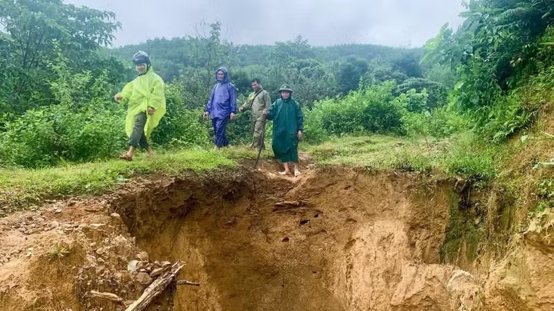
Towards the end of 2025, a sudden landslide on a hillside in Put Village, Hung Son border commune (Da Nang City), resulted in three deaths and missing persons. Throughout 2025, a total of 479 households in the commune were affected by consecutive storms and floods.
Heavy rains also damaged numerous infrastructure facilities, administrative offices, and roads, causing estimated total losses exceeding 125 billion VND. Local authorities organised the evacuation and relocation of 342 households—comprising 1,295 individuals—to safety.
Following the floods, with support from both central and local levels, the Hung Son commune administration provided timely assistance to residents in landslide-affected and isolated areas, helping them recover and stabilise their lives along the Viet Nam-Laos border.
Bhling Deu from H’juh Village, Hung Son Commune, shared: “Our village is home to 87 households and 230 residents. When the landslide occurred, the residents remained safe thanks to the timely inspection by local authorities. We are truly grateful to the Party and the State for their prompt support and care for the people living in this border region.”
Hung Son was previously a model of success in the resettlement and stabilisation of mountain communities in Quang Nam Province. Following a merger, the commune now comprises 12 villages, 2,160 households, and 8,026 residents; the entire population belongs to ethnic minority groups, with livelihoods primarily based on agriculture and forestry.
To proactively respond to natural disasters based on projected risk levels for 2026, Hung Son has developed a response plan and consolidated its commune-level Civil Defence Steering Committee, which now has 325 members.
Nguyễn Văn Kỳ, Vice Chairman of the Hung Son Commune People’s Committee, stated that the commune has identified 676 households and 120 homes located in hazardous or unsafe areas. All 12 villages are at risk during heavy rainfall. Hilly areas, cut slopes, steep inclines, and key transport routes—specifically the ĐH4 and ĐT606 roads—are prone to landslides and rockfalls.
On September 19, after assessing cracks that had long been present at the foot of Pơrlai Mountain in Gari Village, local authorities mobilised the emergency relocation of 40 households (comprising 133 people) to ensure their safety.
“Local authorities have reviewed the entire ‘4-on-the-spot’ force across every village and high-risk area, assigning specific duties to ensure rapid mobilisation should an adverse situation arise; simultaneously, preparations are underway regarding food supplies, centralised evacuation shelters, and search-and-rescue vehicles and equipment,” said Commune Vice Chairman Nguyen Van Ky.
In the mountainous commune of Tra Doc, heavy rains and floods in late October and early November 2025 caused landslides at over 40 locations along transportation routes.
Notably, the DH8.NTM route—which provides access to six villages—suffered complete washouts and landslides at three points, isolating approximately 1,500 households (comprising about 7,000 people) for several days. Thanks to effective response planning, there were no casualties; however, the floods caused significant damage to housing and economic infrastructure.
Phan Duy Hung, Chairman of the Tra Doc Commune People’s Committee, stated that field assessments have identified 251 households (1,220 people) across eight villages who are at direct risk during natural disasters and require evacuation to safe locations. The commune has also finalised its 2026 disaster prevention and control plan, establishing response scenarios tailored to specific risk levels in each village.
In addition to consolidating the commune’s Civil Defence Steering Committee, Tra Doc has conducted training on search and rescue, first aid, equipment operation, and emergency response procedures for heavy rains, storms, floods, landslides, and flash floods, while also stockpiling essential supplies and equipment.
“Despite ongoing challenges posed by the terrain and extreme weather, the locality is committed to proactive, early action—prioritising prevention and building a safe, disaster-resilient community. In the long term, the commune is implementing a scheme to restore headwater forests, protect water sources, and mitigate landslides,” said Phan Duy Hung, Chairman of the Commune People’s Committee.
Developing disaster response scenarios
Following administrative mergers, Da Nang city comprises 37 communes designated as ethnic minority and mountainous areas, along with four additional communes containing villages classified as ethnic minority areas; these cover a total natural area of approximately 7,761 km², accounting for 65.4% of the city’s total territory. The city’s mountainous region is characterized by fragmented terrain and frequently faces landslide risks during the storm and rainy season.
In preparation for the 2026 rainy season, the Da Nang City People’s Committee issued Decision No. 2322/QĐ-UBND on May 26, 2026, approving a disaster response plan based on local risk levels. This plan aims to proactively address specific types of disasters, such as storms, earthquakes, droughts, floods, and inundation.
As part of this initiative, Da Nang has assessed and identified 57 communes and wards at risk of landslides, involving plans for the dispersed evacuation of 6,942 people and the centralized evacuation of 13,588 people.
Truong Xuan Ty, Deputy Director of the Da Nang Department of Agriculture and Rural Development, stated that all 93 communes and wards in the city have now approved their respective disaster response plans.
Mountainous areas must develop specific response plans for flash floods, landslides, and situations involving isolation or being cut off. In the long term, measures should be implemented to gradually control construction in high-risk zones and address activities that obstruct water flow, while simultaneously relocating residents from unsafe areas.
To date, all 93 communes and wards in Da Nang have approved their natural disaster response plans. Mountainous areas are required to develop specific scenarios addressing flash floods, landslides, and situations involving isolation or being cut off from access. In the long term, the city aims to gradually control construction in high-risk zones, address activities that obstruct water flow, and progressively relocate residents from unsafe areas.
Truong Xuan Ty, Deputy Director of the Da Nang Department of Agriculture and Rural Development
The city mandates a shift from simply warning of weather phenomena to warning of potential impacts. This involves identifying areas at risk of flash floods and landslides, locations prone to isolation, and transport routes where traffic must be restricted or prohibited.
Evacuations must be carried out early and target the appropriate groups, ensuring adequate conditions at relocation sites. Local plans must specifically identify households requiring relocation, priority groups, timing, routes, means of transport, support personnel, and reception locations.
Localities must proactively stockpile food and essential supplies in safe locations. Specifically, areas at risk of prolonged isolation must ensure reserves sufficient to meet needs for at least 30 days.
The city’s core strategy focuses on localized risk management, early warning and evacuation, and timely force mobilisation to avoid being caught off guard.
“The city has urged residents to regularly monitor official information, recognise danger signs, prepare self-protection plans, and strictly comply with local authorities' relocation and evacuation orders,” affirmed Truong Xuan Ty, Deputy Director of the Department of Agriculture and Rural Development.

![[In Pictures] Bridge columns and underpasses in Ha Noi begin to turn green](https://en-cdn.nhandan.vn/images/nyM650OGFWrOVWc-xajqN-rTZ68Rlmc1fiGJOhBRYHH_N-Xs0TE8Psnfce7ORTs-KVfoJaEblqjNufFrgeF3e2xFkGtLQVaXm04VcmMKBEkANUyiOkpz4zAuIKgydVrrfBxmGez0E_YJIag0u_Uil0E7jpuJXsIxeMmGjoY1-W4/1791863309074-2994714492692222878-2994714492692222878-adb9ff3f4175c70066ed8bb80cfbead9.jpg.avif)