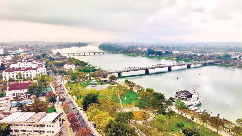
Expanding development space
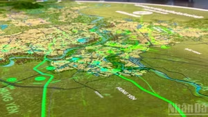
According to the adjusted master plan for Hue City for the 2021–2030 period, with a vision to 2050, approved by the Hue City People’s Council on February 27, Hue’s development space has been expanded in a meaningful way. From a relatively closed heritage city, Hue is shifting to a multi-regional connected structure, stretching from the sea and lagoons to mountainous and border areas. More than 4,900 square kilometres have been restructured into a unified entity, where the sea is no longer a “peripheral edge” but an integral component of the economic structure.
A notable change is that Hue will no longer develop around a single heritage core but will adopt a multi-axis model. The east–west axis and maritime space are now placed on par with the central urban area. Previously, the north–south axis along National Highway 1 was almost the sole backbone, but the plan now establishes the east–west axis along National Highway 49 as a key economic corridor, connecting the centre with mountainous areas and border gates. At the same time, the proposal includes the development of a boulevard in the east to link coastal industrial zones with new urban areas, opening greater potential for utilising lagoon spaces more effectively.
The urban structure is also being redefined in an integrated manner. Hue will no longer be a single-core city centred on heritage but will develop into an urban–rural–ecological ecosystem linked to mountains, forests, lagoons, and the sea. The western and southern areas are oriented towards forest-based economies, organic agriculture, and eco-tourism, while the eastern and southeastern areas are designated for industry, energy, and coastal services.
Service sectors such as trade, healthcare, and education are oriented towards modern, region-leading development. In particular, the formation of service centres and logistics networks linked to the east–west axis through international border gates is expected to boost intra-regional goods circulation as well as imports and exports.
It can be seen that this planning adjustment not only defines what Hue will develop but also clarifies how its space will be organised. The sea and connectivity are placed at the forefront. However, there is always a gap between planning on paper and reality, and that gap is becoming evident in infrastructure connectivity.
Infrastructure pressure and planning delays
National Highway 49 has been identified as the east–west economic corridor; however, in fact it remains a winding, narrow, and weak road with many sharp curves. Meanwhile, this deteriorating road must bear an increasing volume of vehicles, particularly heavy trucks, placing significant pressure on the infrastructure.
Many still recall that in mid-August 2022, a serious traffic accident occurred at Km72 on National Highway 49, when a truck carrying acacia timber collided with two motorbikes and overturned, killing four people and causing hours of traffic congestion. Along the route, there are still many high-risk sections on steep mountain passes, while road surfaces have not been upgraded accordingly. Trucks transporting coal and ore from Laos have increased in number, often travelling at high speeds at night, posing constant risks of accidents.
Tran Van Loi, a truck driver on the Laos–Hue route, said that although he is familiar with the road, he still feels worried when driving on it. "When encountering vehicles coming from the opposite direction on the sharp bend, and they occupy half the road, just a slight steering error can lead to an accident," he said.
Meanwhile, Nguyen Manh Hung, Secretary of the Party Committee of A Luoi 2 Commune, noted that frequent passage of heavy trucks through nearby residential areas has caused serious concern among local residents. Narrow roads and long vehicles often lead to lane encroachment, and when incidents occur, the consequences are severe, and prolonged congestion is unavoidable.
Le Cong Dien, Deputy Director of the Department of Construction, acknowledged that pressure on National Highway 49 is increasing. Authorities are studying solutions to reorganise traffic, including restricting heavy vehicles during certain hours or on specific sections. However, in the long term, he stressed that upgrading and expanding National Highway 49 remains the most appropriate solution if the east–west corridor is to fulfil its role as an economic connectivity axis.
Authorities are studying solutions to reorganise traffic, including restricting heavy vehicles during certain hours or on specific sections. However, in the long term, he stressed that upgrading and expanding National Highway 49 remains the most appropriate solution if the east–west corridor is to fulfil its role as an economic connectivity axis.
Le Cong Dien
Deputy Director of the Department of Construction of Hue City
More than 10 years ago, this route was proposed for upgrading with a total investment of over 1 trillion VND, but the project has not been implemented due to a lack of financial resources. This shows that planning vision has moved ahead, while financial and infrastructure conditions have lagged behind.
The Chan May–Lang Co Economic Zone continues to be identified as a key growth driver in the south in this adjustment. However, after nearly 20 years of development, its general plan from 2008 has revealed many shortcomings, while comprehensive adjustments have only been carried out in the 2024–2025 period. This delay is not only a technical issue but has directly affected people’s lives.
Nguyen Thi Hanh, a resident of An Cu Dong Hamlet, stood before her temporarily fenced land, pointing to the unfinished foundation of her house: “Nearly 10 years ago, I planned to upgrade it for my children, but I was told the land was still under planning, a record was made, and I had to stop upgrading, so it has remained like this ever since.” During the waiting period, planning has not only existed on paper but has affected each plot of land. Many households have faced difficulties in building, repairing houses, or changing land use purposes. “It’s our land, we have the land-use certificate; however, we cannot build or even repair our house,” a resident in the Chan May–Lang Co area expressed frustration.
The city has requested relevant units to accelerate the completion of zoning plans, detailed plans, and land-use plans, considering them the basis for resolving long-standing issues. Along with reviewing delayed projects, the city will adjust the development programme of the Chan May–Lang Co Economic Zone in line with the new planning, while promoting investment in key infrastructure works such as ports, transport systems, and logistics zones.
Hoang Hai Minh
Vice Chairman of the Hue City People’s Committee
Regarding these issues, Hoang Hai Minh, Vice Chairman of the Hue City People’s Committee, said that
The city has requested relevant units to accelerate the completion of zoning plans, detailed plans, and land-use plans, considering them the basis for resolving long-standing issues. Along with reviewing delayed projects, the city will adjust the development programme of the Chan May–Lang Co Economic Zone in line with the new planning, while promoting investment in key infrastructure works such as ports, transport systems, and logistics zones.
However, he also emphasised that the implementation process must ensure a balance between effective management and the legitimate rights of residents, avoiding the emergence of new complications. The adjusted master plan has opened a long-term development direction for Hue. However, an economic corridor can only truly take shape when goods flow smoothly, and an economic zone can only be effective when planning is translated into concrete projects, infrastructure, and livelihoods for local people. These are key challenges that Hue must soon address in its development roadmap.