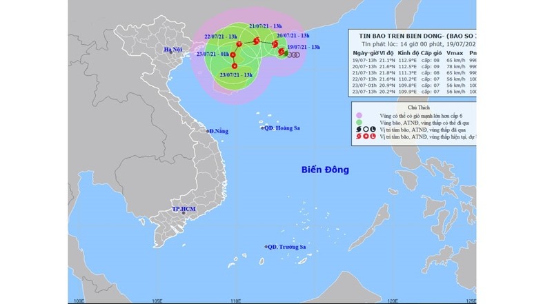
As of 1pm on July 19, the storm’s centre was at about 21.1 degrees north latitude and 112.9 degrees east longitude, about 190 km southeast of Hong Kong (China), packing winds of 60-75 kilometres per hour (level 8), shock at level 10.
For the next 24 hours, the storm will move north-westwards. By 1pm on July 20, the centre of the storm will be at about 21.6 degrees north latitude and 112.5 degrees east longitude, with the strongest winds near the centre at level 8-9 (60-90 kilometres per hour), shock at level 11.
The danger zone in the East Sea/South China Sea in the next 24 hours will be at 19.5 degrees north latitude and 111.0-114.5 degrees east longitude.
In the next 24-48 hours, the storm will move west-north-westwards at speeds of 5 kilometres per hour. By 1pm on July 21, the storm’s centre will be about 21.8 degrees north latitude and 111.3 east longitude on the mainland southwest of Guangdong province (China), with strongest winds near the centre at level 8 (60-75 kilometres per hour), shock at level 10.
For the following 48-72 hours, the storm is likely to change direction and move south-westwards at a speed of 5 kilometres per hour, gradually weakening into a tropical depression.
As of 1pm on July 22, the depression’s centre was at about 21.6 degrees north latitude and 110.2 degrees east longitude on the mainland southwest of Guangdong province (China), with strongest winds near the centre at level 7 (50-60 kilometres per hour), shock at level 9.


