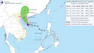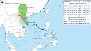
Authorities have issued warnings of a high risk of flooding in low-lying areas along the Ca River in the central province of Nghe An, as well as potential flash floods along small rivers and streams, and landslides on steep slopes in mountainous regions in the locality.
Between the morning and night of July 25, the northwest region as well as the provinces of Thanh Hoa and Nghe An are forecast to experience moderate to heavy rain and thunderstorms, with common rainfall of 30 – 60mm. Other parts of northern Viet Nam may see scattered showers and thunderstorms.
From the night of July 26 to the night of July 27, areas in the central region from Ha Tinh to Da Nang are expected to receive moderate to heavy rain and thunderstorms, with rainfall of 60 – 120mm and potentially over 200mm.
There is also a warning of intense localised rainfall exceeding 100mm in a three-hour period.
Heavy rains in the north, as well as in Thanh Hoa and Nghe An, would gradually ease from July 26. Rainfall in the region from Ha Tinh to Da Nang may begin to decrease from July 28.
The overall disaster risk level associated with the heavy rain, thunderstorms, lightning, and hail remains at Level 1 – the lowest on the national hazard scale.