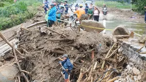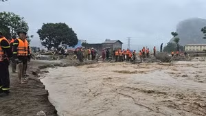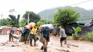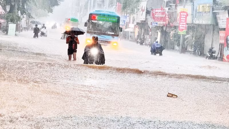
According to statistics from the Ministry of Construction, more than 70% of urban areas in Viet Nam are regularly affected by flooding after heavy rainfall or high tides. Major cities such as Ha Noi and Ho Chi Minh City have invested tens of trillions of VND into anti-flooding projects, however, results remain limited. Flooding occurs not only in low-lying areas but also in central districts, where drainage infrastructure was built a long time ago and can no longer meet demand at present.
The fact shows that each rainy season brings severe flooding in many cities, paralysing socio-economic activities for hours or even days. Rainwater inundates key transport routes, damaging works, vehicles, and production and business facilities. Beyond economic losses, flooding disrupts daily life and increases risks to public health and safety.
The worsening situation reflects not only shortcomings in infrastructure but also limitations in traditional urban management work. It highlights the urgent need to accelerate the application of science and technology in forecasting, monitoring, and operating drainage systems, moving towards proactive, large-scale, and sustainable flood control solutions for urban areas.
According to statistics from the Ministry of Construction, more than 70% of urban areas in Viet Nam are regularly affected by flooding after heavy rainfall or high tides.
According to Prof. Dr. Nguyen Viet Anh, Vice President of the Viet Nam Water Supply and Sewerage Association, there are currently no specific regulations on the use of meteorological data. In addition, hydraulic and hydrological simulation software has not been fully updated or consistently shared among sectors. Citing the experiences of other countries in the region, he said that Japan is among the most effective countries in controlling urban flooding by combining large-scale infrastructure investment, public-private partnership (PPP) mechanisms, and strong digital transformation application.
Japan deploys IoT sensor systems to monitor rainfall, water levels, and flow in real time, while operating Digital Twin models — digital urban replicas — to simulate flooding, assess risks, and issue early warnings for people. Cities such as Tokyo and Yokohama have implemented real-time flood maps down to neighbourhood level. Meanwhile, the Republic of Korea (RoK) has built a “Master Plan for Urban Flood Control”, investing in underground retention facilities and building national digital platforms integrating meteorological, drainage, and transport data.
A green and smart urban area cannot allow flooding to worsen year after year. Accordingly, Viet Nam needs to develop a national database on urban flood, flood maps, and shared meteorological data; apply GIS, IoT, predictive modelling and early warning systems, integrated into smart city operation centres. In the short term, pilot models of “smart flood-resilient cities” could be implemented in Ha Noi and Ho Chi Minh City to gain experiences before scaling up nationwide.
Sharing this view, Prof. Dr. Tran Duc Ha emphasised that many countries have adopted Location-Based Services (LBS) map for flood management and warning. This technology combines GPS, mobile networks (3G/4G, GSM), and Wi-Fi to accurately determine device locations, thereby displaying real-time flood information on a digital map, supporting citizens and authorities in proactively responding. According to him, Viet Nam needs to build capacity for disaster prevention and response, including urban flood control, through the establishment of an early warning system and improved local operational capacity.
Such systems are designed to monitor, forecast and support the synchronous operation of pumping stations, sluices, and retention lakes before, during, and after rainfall, based on digital data and the application of artificial intelligence in drainage management. Urban flood monitoring and warning systems should be built on GIS platforms, integrating X-band radar stations, rainfall and water-level sensors, and centralised operation centres. Data would be continuously updated, analysed, and announced in a timely fashion via digital platforms, while integrated software calculates rainfall, river, and lake levels, and predicts flood risks based on actual measured data, ensuring high accuracy in analysing rainfall and flood development and the drainage system's carrying capacity.
In fact, climate change is clearly increasing flood risks in Viet Nam. Forecast models show more frequent and intense extreme rainfall events. Many cities will face short-duration “rain bombs” exceeding the design capacity of drainage systems. Meanwhile, sea-level rise is reducing natural drainage capacity in coastal cities such as Ho Chi Minh City and Da Nang. When high tides coincide with heavy rainfall, water from rivers and the sea flows back into drainage systems, worsening flooding. These trends demonstrate that traditional approaches focused only on rapid drainage are no longer sufficient.
It is estimated that by 2045, Viet Nam will require around 10 billion USD (approximately 270 trillion VND) for urban flood control. To use these resources effectively, experts said that the need for comprehensive, long-term solutions, in which technological application plays a key role — from building flood maps and early warning systems to real-time forecasting models, smart drainage management, and GIS-based data digitalisation, creating a shared database to serve the management and operation.
Urban flooding is a complex challenge that cannot be solved through piecemeal measures. It requires a fundamental shift in planning mindset, combining infrastructure development with advanced technology application. With their potential and position, Vietnamese cities, if they make decisive changes, can absolutely become models of cities that are resilient and adaptive to climate change.