In the context of complicated climate change, Viet Nam belongs to the group of countries heavily impacted, not only in coastal and lowland areas, but also in the midland and mountainous regions, where the terrain is complex, infrastructure is limited, and the level of vulnerability is high.
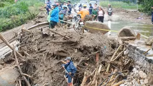
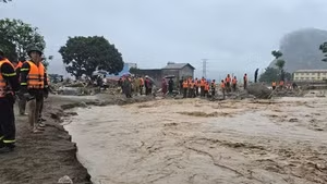
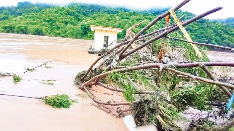
Notably, mountainous cities with limited resources and livelihoods dependent on nature face direct risks such as flash floods, landslides, droughts, and water resource depletion every time the rainy season arrives.
This necessitates an urgent shift from a single-sector planning approach to a comprehensive, multi-sectoral thinking to enhance adaptability.
Recognising this issue, the Party and Government have paid special attention to the planning and management of mountainous urban development to adapt to climate change. Many important policies and guidelines have been issued, such as: the Viet Nam Urban Development Plan to Respond to Climate Change for the 2021-2030 period, along with related legal systems (Construction Law, Architecture Law, Urban and Rural Planning Law, etc.), all of which have integrated the requirement to assess natural disaster risks and adapt to climate change in planning.
At the same time, the planning for the Northern Midlands and Mountainous region for the 2021-2030 period, with a vision to 2050, has been approved, creating a framework for sustainable development orientation for localities.
Based on this, many localities have proactively developed plans and implemented climate change response programs in urban development, with support from international organisations and pilot models in some areas. However, the integration of climate change content into local-level planning, especially in mountainous areas, is still uneven and lacks depth, requiring more comprehensive and decisive solutions in the future.
Sharing on this issue, Professor, Dr. Do Hau, from the Viet Nam Urban Planning and Development Association, said that in many localities, economic and infrastructure development is still prioritised over systematic climate risk management. Therefore, urban planning in mountainous areas often fails to adequately forecast specific risks such as flash floods, landslides, droughts, or water shortages from the design stage, resulting in plans lacking proactiveness and response capabilities.
Furthermore, land allocation, infrastructure development, and construction management in many mountainous urban areas have not been updated in a timely manner according to new climate data; the infrastructure system for resilience to extreme weather events is still lacking and weak.
Notably, climate change has not yet been placed at the center of planning, especially at the local level, due to a lack of long-term vision and risk forecasting mechanisms. Simultaneously, the climate data system has not been fully integrated and updated; the capacity for applying technology, forecasting, and monitoring is limited due to a lack of resources.
Modern tools such as GIS (data collection, management, and analysis tools) and risk simulation have not been widely deployed, while community participation remains weak, reducing the effectiveness of adaptation in practice.
Many experts also believed that urban planning and development management in mountainous areas of Viet Nam still have many limitations, lacking integrated planning, and urban infrastructure has poor resilience. Urban governance institutions and models remain fragmented...
In this context, a shift from a single-sector, single-level, and short-term approach to urban planning and development management to a comprehensive, multi-level, and multi-sectoral approach is urgently needed in the planning and management of mountainous urban development. A synchronised and integrated approach between space, infrastructure, and governance institutions is essential.
Viet Nam is considered one of the countries most severely affected by climate change. These impacts are no longer distant predictions but are already evident through extreme weather events occurring with increasing intensity and frequency, directly threatening the livelihoods of millions of people.
According to Associate Professor, Dr. Hoang Thai Dai, Viet Nam Irrigation Association, forecasts for 2026 indicate that Viet Nam will face a transition in ENSO phases from La Nina (cold phase) to neutral, with the potential for El Nino (warm phase) to form by the end of the year. This transition is often accompanied by unpredictable extreme weather risks, including intense heatwaves from March and the risk of flash floods and sudden landslides during the rainy season.
Therefore, adapting to climate change requires synchronised investment in forecasting and early warning systems and disaster prevention and mitigation infrastructure in vulnerable areas. Viet Nam needs to prioritise budget allocation for integrating adaptation goals into national target programs, especially in ethnic minority and mountainous regions, where the resilience of the people is still low.
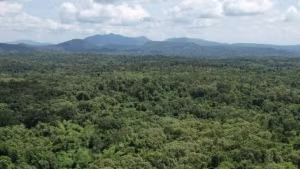
To address this situation, Professor and Doctor Do Hau suggests integrating climate change scenarios and natural disaster risk zoning (flash floods, landslides, mudslides) into land use and construction planning. Using natural disaster risk maps as a legal basis for determining areas where construction is prohibited or development is restricted is crucial for guiding urban spatial development and controlling population expansion. Urban planning in mountainous areas should prioritise adapting to steep terrain, protecting headwater forests, vegetation, and ecological landscapes.
Based on international experience, experts believe that many countries have proactively designed urban infrastructure in mountainous areas to adapt to climate risks. For example, Switzerland has built transportation systems to withstand landslides, avalanches, and extreme rainfall; Chile applies decentralised drainage combined with green infrastructure for hillside cities. Simultaneously, community-based risk management models have been effectively implemented in Nepal and India; in Peru, people participate in monitoring landslides and managing water resources...
This shows that mountainous urban areas in Viet Nam need to shift strongly towards adaptive, flexible, and nature-based development; prioritising appropriately scaled, dispersed infrastructure, enhancing green infrastructure, while promoting the role of the community and fostering sustainable livelihoods linked to resource conservation.
![[Video] Viet Nam to allocate at least 2% of annual state budget for environmental protection](https://en-cdn.nhandan.vn/images/8f440db7b9bfe62cb5397a6750a8b01baf75985d773fc6617e8284531240c6f952553ffd2d04ad2cc22885322a297da9e9025c2d7944d75148de8ee1664be9e4/31-7-5074.jpg.avif)