Alongside this, the integration of multi-source data—from satellites, radar, and automated observation stations to lightning detection systems—has enabled the development of real-time weather monitoring. As a result, hazardous phenomena such as thunderstorms, whirlwinds and hail can now be forecast between 30 minutes and three hours in advance, with steadily improving accuracy.
A particularly noteworthy development is the application of artificial intelligence (AI). AI models not only assist in automatically identifying the location and intensity of storms, but can also learn from historical data to enhance forecasting. In the short term, storm intensity forecasting has improved by 10–20%.
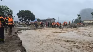
In hydrology, flood and saltwater intrusion forecasting models based on river basins, combined with international data—especially for the Mekong River basin—have extended warning lead times to several days, enabling local authorities to respond more proactively. At present, real-time flash flood and landslide warning systems, updated hourly and down to commune level, are gradually bringing technology closer to the public.
Despite these advances, a considerable gap remains between practical demands and forecasting capacity. First, the scientific and technological workforce has yet to keep pace with development needs. Observation networks remain inconsistent, data lacks interoperability, and open data standards are not fully established. Investment in research is still limited, financial mechanisms lack flexibility, and socialisation remains difficult. Moreover, there is a shortage of policies to encourage and attract scientists and research organisations, as well as support mechanisms for testing and applying new technologies under real-world conditions.
From a technical perspective, while storm track forecasting has seen some improvement, errors remain significant; meanwhile, storm intensity forecasting has shown little clear progress over the past 15 years. Rainfall forecasting by even the most advanced numerical models continues to exhibit low accuracy. For 1–3 day forecasts involving rainfall thresholds exceeding 50 mm per 24 hours, accuracy rates stand at only 15–20%.
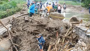
Early forecasting of flood peaks on rivers in the northern and central regions also remains limited. It is not yet possible to provide detailed warnings of flash floods and landslides at specific residential or infrastructure locations due to the lack of real-time geological and topographical observation data.
Four key pillars should be prioritised: mastering core technologies, particularly AI and ensemble forecasting models; developing intelligent real-time observation systems; strengthening big data processing capabilities; and improving the effectiveness of delivering warning information to the public. Immediate priorities include enhancing the accuracy of storm intensity forecasts, aiming to reduce errors to below 7 m/s, while improving the ability to detect and predict sudden intensification of storms in the East Sea/South China Sea.
Nguyen Xuan Hien, Deputy Director of the National Centre for Hydro-Meteorological Forecasting
Accordingly, to improve the effectiveness of forecasting and early warning, Nguyen Xuan Hien, Deputy Director of the National Centre for Hydro-Meteorological Forecasting, emphasised the need to focus on the four key pillars: mastering core technologies, especially AI and ensemble forecasting models; developing intelligent real-time observation systems; strengthening big data processing capacity; and improving the dissemination of warning information to the public. Priority should be given to improving storm intensity forecasting accuracy, striving to reduce errors to below 7 m/s, while enhancing the capability to identify and forecast sudden storm intensification in the East Sea/South China Sea.
At the same time, quantitative rainfall forecasting needs to be significantly improved, aiming for accuracy rates exceeding 60% for common rainfall thresholds and over 40% for dangerous heavy rainfall thresholds, thereby enhancing the effectiveness of flood and inundation warnings. A fundamental task is to develop a detailed and synchronised training data system, combining meteorological grid data with actual observations, to support the development and application of AI models in forecasting storms and heavy rainfall in Viet Nam.
Efforts should be intensified to apply AI in identifying, analysing and issuing early warnings of major floods across river basins 2–5 days in advance, based on hazardous rainfall scenarios; and to closely integrate hydrological–hydraulic models with AI technologies to improve short- and very short-term flood forecasting.
Efforts should be intensified to apply AI in identifying, analysing and issuing early warnings of major floods across river basins 2–5 days in advance, based on hazardous rainfall scenarios; and to closely integrate hydrological–hydraulic models with AI technologies to improve short- and very short-term flood forecasting.
In addition to technological factors, according to Le Cong Thanh, Deputy Minister of Agriculture and Environment, one key direction is to ensure that disaster forecast and warning information reaches the public as quickly and accessibly as possible, through digital platforms, mobile applications and multi-channel communication systems.

![[Video] Viet Nam to allocate at least 2% of annual state budget for environmental protection](https://en-cdn.nhandan.vn/images/8f440db7b9bfe62cb5397a6750a8b01baf75985d773fc6617e8284531240c6f952553ffd2d04ad2cc22885322a297da9e9025c2d7944d75148de8ee1664be9e4/31-7-5074.jpg.avif)