Early forecasting — the first line of defence
Between 2021 and 2025, the country experienced on average around 10-12 storms and tropical depressions each year, along with hundreds of episodes of heavy rain, flooding, and landslides. Over the five-year period, disasters left more than 1,500 people dead or missing and caused economic losses amounting to hundreds of trillions of Vietnamese dong.
Notably, many types of disasters have emerged with new characteristics, such as flash floods and landslides in mountainous areas, extreme rainfall in urban centres, and drought and saltwater intrusion in the Mekong Delta. These phenomena often occur rapidly, over a limited area, yet they cause severe damages and are difficult to forecast.
According to Deputy Minister of Agriculture and Environment Le Cong Thanh, the more accurate the forecast and the earlier the warning, the greater the ability to respond proactively, thereby significantly reducing losses. In practice, forecasting and early warning serve as the first line of defence, playing a decisive role in safeguarding lives and property.
Dr Nguyen Xuan Hien, Deputy Director of the National Centre for Hydro-Meteorological Forecasting, noted that climate change is intensifying extreme weather patterns globally, including in Viet Nam.
During 2011-2020, the global average surface temperature rose by approximately 1.09°C compared with pre-industrial levels. The period from 2015 to 2025 includes the 11 hottest years in the past 175 years. In 2025, temperatures were 1.44°C higher than in 1850-1900, making it the third warmest year on record.
In Viet Nam, a number of extreme events have been recorded, such as the severe drought and saltwater intrusion in the Mekong Delta during the 2019-2020 dry season, and the historic floods in the central region in 2020.
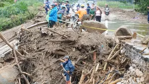
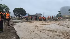
Specifically, Typhoon Yagi in September 2024 was assessed as the strongest in 30 years in northern Viet Nam, bringing record-breaking rainfall, historic flooding, and severe landslides. In 2025, the number of storms and tropical depressions in the East Sea/South China Sea also reached a record high, alongside extreme phenomena such as daily rainfall at Bach Ma Station (Hue) reaching 1.74 metres and major floods occurring simultaneously across 21 river systems.
These developments underscore the urgent need to enhance forecasting and early warning capacity to minimise damage.

Strengthening forecasting capacity and overcoming challenges
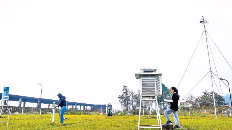
According to experts, Viet Nam’s hydrometeorological forecasting system has made significant progress in recent years. Numerical forecasting models operating on supercomputers now provide detailed data at a resolution of 3x3 km. Storm forecasting is conducted using ensembles of global and regional models combined with data assimilation technologies.
The application of artificial intelligence is delivering clear benefits. Machine learning models have improved short-term storm intensity forecasts by 10-20%, while automated storm detection from satellite data achieves accuracy rates of over 90%.
In forecasting thunderstorms and tornadoes, integrated systems using data from satellites, radar, lightning detection, and rain gauges can provide warnings 30 minutes to three hours in advance, with accuracy ranging from 70 to 90%. Platforms for flash flood and landslide warnings have also been deployed in real time, updated down to the commune level.
Hydrological forecasting has continued to improve, with flood forecasts for rivers in northern and central regions ranging from 12 to 48 hours ahead, and up to five days in the south; early warnings can be issued two to four days in advance, and even up to 10 days in some areas.
However, challenges remain. The accuracy of heavy rainfall forecasts is still limited; long-term forecasts of storm intensity have seen little improvement; and lead times for predicting flood peaks remain short. The issuing of precise warnings for flash floods and landslides at specific locations remains particularly difficult due to a lack of real-time geological and topographical data.
In addition, data infrastructure, observation networks, and scientific and technological human resources have yet to meet requirements, while financial mechanisms and policies to attract resources for research and technological application remain constrained.
Cao Duc Phat, Chairman of the Community Fund for Disaster Prevention, emphasised that in the face of increasingly extreme disasters, enhancing accurate forecasting and early warning capacity is a prerequisite for grassroots authorities and communities to take proactive measures and minimise losses.
In response to these demands, Deputy Minister Le Cong Thanh stressed that accelerating the application of modern technologies such as AI, big data, remote sensing, and high-resolution numerical models would open new directions for the hydrometeorological sector.
According to the Ministry of Agriculture and Environment, digital transformation in hydrometeorology will be advanced through the development of large-scale data systems, modernisation of observation networks, the creation of multi-hazard early warning platforms, and enhanced data sharing.
A key requirement highlighted is to deliver forecast and warning information to the public as quickly and accessibly as possible via digital platforms, mobile devices, and multi-channel communication systems.
In the coming period, the hydrometeorological sector aims to further promote digital transformation, master advanced forecasting technologies, and improve the quality of storm intensity forecasts, rainfall quantification, and flood warnings, while also developing early warning systems with greater localised detail, strengthening real-time data connectivity, and ensuring that people can access information promptly and effectively.

![[Video] Viet Nam to allocate at least 2% of annual state budget for environmental protection](https://en-cdn.nhandan.vn/images/8f440db7b9bfe62cb5397a6750a8b01baf75985d773fc6617e8284531240c6f952553ffd2d04ad2cc22885322a297da9e9025c2d7944d75148de8ee1664be9e4/31-7-5074.jpg.avif)