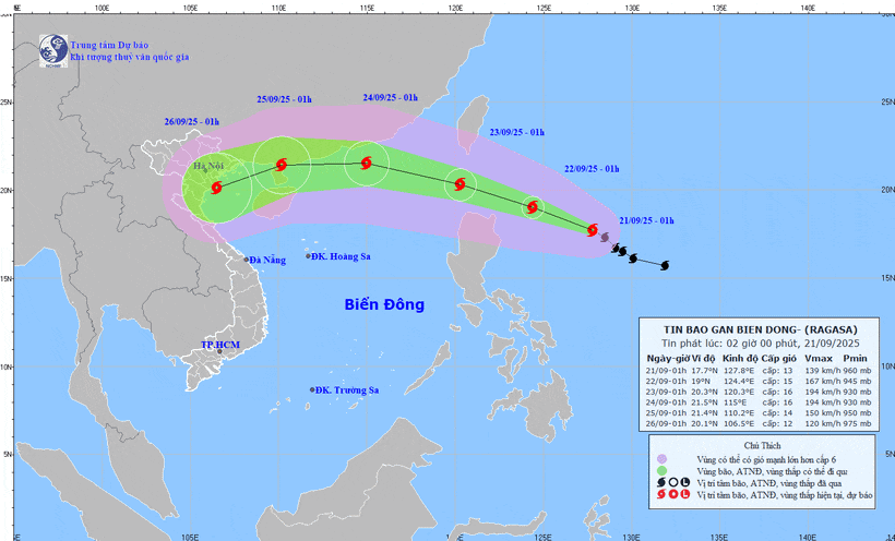
Its movement is complicated, and the National Centre for Hydrometeorological Forecasting (NCHMF) predicts two scenarios: either the storm will hit China and weaken before affecting Viet Nam, or it will veer westward and make direct landfall here.
Nguyen Van Huong, head of the Weather Forecasting Division under the NCHMF, said that Ragasa is set to be the first super typhoon in the Northwest Pacific region this year.
The path of the typhoon is still relatively complex to predict, and international forecasts vary considerably.
Some experts expect that as Ragasa approaches the 120th meridian, it will turn northward toward Taiwan (China). Under this scenario, the system would have minimal impact on Viet Nam.
However, the highest probability is that Typhoon Ragasa will enter the East Sea/South China Sea on September 23, becoming the ninth storm, with two possible pathways.
The first potential scenario is that the typhoon hits land in China's Guangdong province, passes the Leizhou Peninsula (also in China), and then affects mainland Viet Nam with a significantly weakened intensity.
The second, and worst-case scenario, is that once in the East Sea, the typhoon primarily moves westward, making landfall in northern and central Viet Nam. Although its intensity may weaken after passing Hainan Island in China, it would still have a strong impact.
Huong said that regardless of which scenario the typhoon follows, from September 25 to 27, the northern and central regions from Thanh Hoa province to Hue city are highly likely to experience heavy rains and strong winds.
The NCHMF said that by 1am on September 23, the typhoon’s centre will likely be over the northern waters of Luzon Island in the Philippines. The natural disaster risk level is level four.
On September 24, the typhoon is expected to maintain its direction while accelerating to 20-25km per hour. By 1am on this day, its centre will be about 140km southeast of Hong Kong (China).
Winds are likely to remain at super typhoon strength of more than 200km per hour.
Afterwards, experts believe the typhoon is likely to move westward before turning west-southwest, travelling at about 20km per hour, with gradually weakening intensity.
The NCHMF is closely monitoring Typhoon Ragasa’s developments. Authorities and residents are advised to keep updated on typhoon forecasts, especially short-term warnings, to respond in a timely manner and ensure the safety of lives and property.