Monitoring and early warning
During the floods in late October 2025, for the first time, residents of Hue heard warning sirens echoing across the city centre and residential areas. Dang Van Hoa, Head of the Sub-department of Irrigation and Climate Change under the Department of Agriculture and Environment, said that since 2024 the city has installed four high-capacity loudspeaker clusters for disaster warnings and issued a three-tier alert protocol. At the highest level, the system emits five siren blasts, each lasting 30 seconds with five-second intervals, repeated no more than three times, to warn of floods exceeding level 3, emergency storms, or tsunamis.
Since 2024, the city has installed four high-capacity loudspeaker clusters for disaster warnings and introduced a three-tier alert protocol. At the highest level, the system emits five siren blasts, each lasting 30 seconds with five-second intervals, repeated no more than three times, to warn of floods exceeding level 3, emergency storms, or tsunamis.
Dang Van Hoa,
Head of the Sub-department of Irrigation and Climate Change under the Department of Agriculture and Environment
On the afternoon of October 26, when the civil defence command activated the warning system and raised the alert level in the early hours of October 27, residents in central Hue had time to prepare and were not caught off guard by a flood whose water level was only slightly lower than the historic November 1999 flood that claimed 350 lives.
“I was riding my car when I heard the siren. At first, I didn’t know what was happening. Then my phone alerted me about major flooding. Looking at the map on the Hue-S application and seeing the Huong (Perfume) River rising rapidly, I immediately moved my vehicle to higher ground. By evening, Hue was submerged,” recalled Nguyen Man, a taxi driver on Le Duan Street.
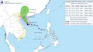
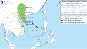
At the city’s operations centre, updates on water levels of the Huong River and Bo River, as well as discharge flows from the Ta Trach, Binh Dien, and Huong Dien reservoirs, were broadcast continuously. Residents at home or at evacuation sites could follow the information on their phones, while local authorities activated systems to receive emergency assistance requests via text messages. In recent years, Hue has invested heavily in automated flood monitoring systems.
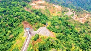
At the same time, an integrated reservoir management system supported by JICA has connected three major reservoirs in the Huong River –Bo River basin. Data from X-band radar, cameras, and water-level sensors are updated continuously, enabling authorities to regulate discharges more effectively and minimise downstream damage.
According to Hoang Hai Minh, Vice Chairman of the Hue City People’s Committee, the city uses 10-day forecasts from the National Centre for Hydro-Meteorological Forecasting to operate reservoirs. This allows sufficient time to lower water levels in preparation for floods, proactively reducing and controlling downstream impacts. Hue has also piloted a “multi-channel, multi-layer” communication model, combining warning sirens, SMS messages, official fan pages, mobile applications, and social media, to ensure that no resident is left outside the information network, said Nguyen Xuan Son, Director of the Department of Science and Technology.
However, the October 2025 floods exposed certain limitations. Widespread power outages caused many warning stations and cameras to cease operation, while disrupted transmission lines slowed data updates. The city is now considering additional backup power, installing solar panels, using LoRa networks, and reinforcing antenna systems to withstand level-12 winds at critical sites to ensure communication under all circumstances.
Signals of a proactive, adaptive city
In peri-urban areas such as Hoa Chau Ward, Tran Van Nhan (62) still maintains the habit of climbing onto the “tra” (a small loft beneath the roof) whenever heavy rain is forecast. “Houses in Hue used to have a tra to store rice and valuables against floods,” he said. “But in 1999, the water rose so fast that just as I lifted my child up, it had already reached the roof. We had to break through the tiles to escape. That’s when I realised that old experience might no longer be enough.”
After four consecutive floods within the final 20 days of 2025, many residents acknowledged that “floods today are not like before”. Urbanisation has altered flood maps: new roads, residential areas and embankments have disrupted natural flows, causing deeper flooding in some places and faster drainage in others. In Quang Dien, once a chronically inundated area, water now recedes more quickly thanks to canal systems draining into Tam Giang Lagoon, while some new residential areas have seen water levels rise to 70cm. Roads such as Vo Van Kiet have effectively become temporary dykes, creating water level differences of up to half a metre on either side.
Older residents admit that traditional knowledge is no longer sufficiently accurate. “It can be sunny here while it’s pouring upstream. Without checking the phone, you wouldn’t know what’s happening,” said Le Thi Thao from An Cuu Ward. Meanwhile, younger generations are learning to “live with data”, with hourly updates, flood maps, and traffic information available during each storm.
“Kids nowadays check apps faster than they watch television. Once, during a flood, they looked at their phones and then pulled the whole family to an evacuation site. It was only after we got there that I realised there had been heavy rain upstream, the reservoirs were full and had lost their capacity to regulate, so moving to higher ground was the only safe option,” Nhan recalled.
Hue City is currently adjusting its urban planning towards greater climate adaptation: expanding detention ponds, upgrading drainage systems, and relocating residents from high-risk areas. Schools and community centres in peri-urban zones have been designated as temporary evacuation sites. Twenty-six years after the historic 1999 flood, Hue has shifted from a passive to a proactive approach to disaster response. From warning sirens to minute-by-minute data streams, the city is taking its first steps on the path towards becoming a climate-resilient urban area.
In this land, the sound of warning sirens will no longer be a signal of fear, but rather the sign of a city that is proactively adapting — better prepared for nature and for its own future.