Viet Nam is among the countries most vulnerable to climate change. To respond, the Government has issued the National Climate Change Adaptation Plan for the 2021–2030 period, with a vision to 2050 (Decision No. 1422/QD-TTg dated November 19, 2024). However, these plans remain largely at the policy level and have yet to receive adequate investment for concrete adaptation actions.
According to the World Bank (WB), Viet Nam needs to invest approxWorld Bankimately 368 billion USD from now until 2040 for adaptation and mitigation efforts. This figure is estimated to account for about 6.8% of GDP annually.
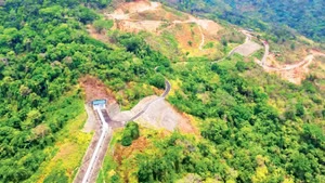
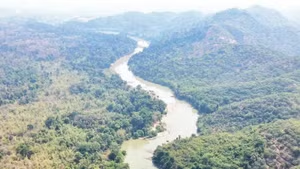
Coastal afforestation projects in Ca Mau have proven effective in reducing erosion and protecting coastal land of the Fatherland.
From scenario to reality
The most recent climate change scenario was published in 2020. After 15 years, climate change is no longer a threat but a clear reality, and developments are trending beyond the published scenarios.
The record for the hottest years in history, as documented by the World Meteorological Organization (WMO), has occurred in the past five years (from 2020–2025). In particular, the consecutive heatwaves during 2023–2024–2025 saw the global average temperature exceed the 1.5°C threshold in 2024.
Moreover, significant instability in the climate system has led to periods of extreme drought, alternating with severe flooding years associated with La Nina, following drought years caused by El Nino.

The situation is becoming more severe, as the latest climate change scenario based on the Sixth Assessment Report (AR6) of the Intergovernmental Panel on Climate Change (IPCC) forecasts that global temperatures will continue to rise, reaching approximately 1.5–1.7°C above pre-industrial levels (1850–1900) during 2030–2050 (depending on the scenario).
Thus, the goal of limiting global warming to no more than 1.5°C under the Paris Agreement is nearly unattainable, and we must prepare for a worse scenario: global temperatures exceeding the 1.5°C threshold. When that occurs, global warming will destabilize the atmospheric system, leading to increasingly irregular extreme weather events.
For Viet Nam, climate change is also reflected in meteorological records in recent years. In 2023, the Hoi Xuan station (Thanh Hoa) recorded a temperature of 44.1°C on May 6, 2023, breaking the previous record of 43.4°C in Huong Khe (Ha Tinh) in 2019.
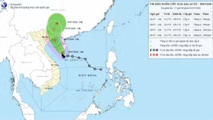
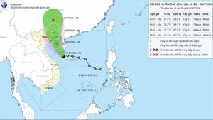
Regarding rainfall, on October 27, 2025, the Bach Ma rain gauge recorded 1,739 mm within 24 hours - the second-highest daily rainfall ever recorded globally in meteorological history.
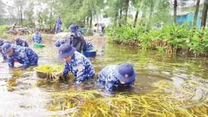
Natural disasters have caused severe damage to people’s lives and livelihoods and significantly affected the national economy.

According to data from the Department of Dyke Management and Natural Disaster Prevention and Control, years with substantial economic losses included 2017 (60 trillion VND), 2020 (35.5 trillion VND), and 2024 (88.748 trillion VND).
Particularly in 2025, natural disasters caused losses exceeding 100 trillion VND. These represent enormous economic damages, slowing national development goals and causing long-term impacts on people’s livelihoods.

Major challenges for Viet Nam
According to the latest climate change scenario announced by the Ministry of Agriculture and Environment, during 2030 - 2050, the national average temperature will increase by 1.1–1.5°C, the number of days with temperatures above 35°C is expected to increase by 15–30 days per year, and rainfall will increase by 5–15% nationwide.
Along with rising temperatures and rainfall is an increase in extreme disasters such as record-breaking heatwaves, major floods, and strong storms. Sea-level rise due to climate change also poses significant risks of tidal inundation in low-lying areas, particularly tidal flooding in Ho Chi Minh City and provinces in the Mekong Delta.
This will present major challenges for climate change adaptation in the next 10–20 years. Combined with difficulties in mobilizing enormous budgets for adaptation and mitigation, it requires flexibility in selecting appropriate adaptation solutions for each stage.
Enhancing Infrastructure Resilience
Infrastructure must be identified as the direct “shield” against extreme climate phenomena. Priority should be given to reassessing disaster risks based on historical disaster levels, such as dykes, dams, and reservoirs in provinces that have experienced historic floods, including Thai Nguyen, Lang Son, Bac Ninh, Nghe An, Quang Tri, Hue, Da Nang, Dak Lak, Khanh Hoa, and Lam Dong.
, known as an international “bird station.”")
Load-bearing thresholds of dams and dyke systems must be determined to upgrade infrastructure resilience against extreme rainfall events previously recorded. Each province and city should calculate flood-resistance thresholds based on cost-benefit analysis and ecological harmony.
Besides public infrastructure such as dykes and drainage systems, the Government and citizens must collaborate to build residential houses and community buildings capable of withstanding region-specific extreme disasters.
In mountainous areas, housing must withstand flash floods and landslides; in lowlands, houses must resist flood levels based on historical records; and in coastal regions, houses must withstand strong typhoon winds.
 frequently faces pressure from large waves hitting the shore. (Photo: Nguyen Thanh–VNA)")
Ecosystem-based adaptation and science–technology application
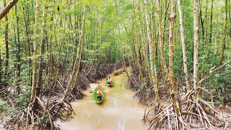
Instead of merely “fighting” nature, Viet Nam must shift toward living in harmony with and leveraging ecosystems, prioritizing the protection of upstream forests, wetlands, and coastal mangrove forests. These “green walls” help mitigate climate extremity while reducing greenhouse gas emissions, contributing to Viet Nam’s Net Zero commitment at COP26. At the same time, the legal framework for selling forest carbon credits should be completed to generate revenue for reinvestment in adaptation projects.
 under the national science and technology project “Research on optical sensor technology and design development of automatic, remote monitoring systems applied in Viet Nam’s marine environmental monitoring” (Code DTDL.CN-92/21).")
In addition to forest and wetland protection, nature-based solutions should be applied in river and sea dyke protection. Limit concrete interventions on long-formed sandy beaches and avoid encroaching upon flood storage spaces in river basins and urban areas.
To adapt to saltwater intrusion and sea-level rise, agricultural and aquaculture production structures must be adjusted flexibly, shifting from monoculture rice farming to “shrimp–rice” or “shrimp–forest” models to utilize saline water instead of attempting to eliminate it.
Artificial intelligence and big data , including historical data, real-time hydro-meteorological monitoring data, and forecast data, should be used to develop disaster risk maps for each region and area. Based on this, real-time disaster warning maps can be built to support planning and disaster response decision-making.