The Red River’s role in Ha Noi’s spatial identity
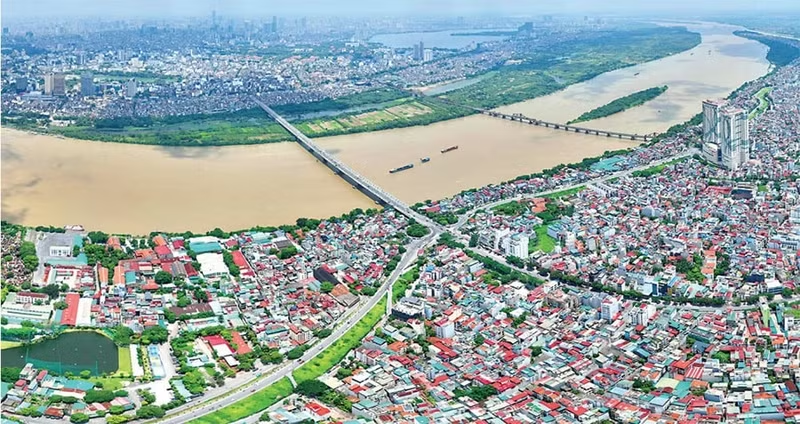
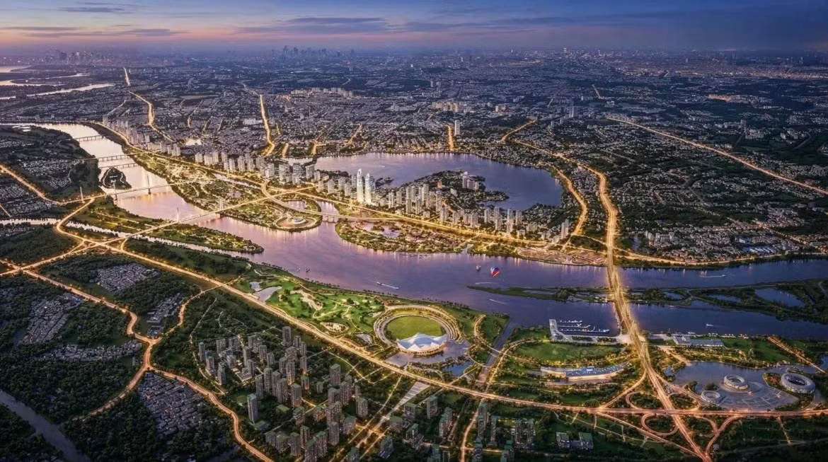
From French colonial planning documents to the Capital’s Master Plan for 2021–2030 with a 2050 vision, the 2065 vision plan and the 100-year master plan for Ha Noi, the Red River’s role has shifted dramatically — from a peripheral “fringe” to a central landscape axis uniting historical and modern cultural heritage.
It is envisioned as a vast public realm of parks, squares and recreational spaces, regulating the climate and shaping a distinctive identity for Ha Noi in a new era of development.
Designating the Red River as the principal scenic axis enables Ha Noi to move beyond a unipolar model towards a polycentric, modern, green and sustainable urban form. The river is not only a green lung and ecological adaptation space but also a strategic axis uniting the “city on both banks”, forming a symmetrical urban structure that treats the river as a façade.
Red River is not only a green lung and ecological adaptation space but also a strategic axis uniting the “city on both banks”, forming a symmetrical urban structure that treats the river as a façade.
It is simultaneously a heritage and cultural corridor, linking communal houses, temples, historic monuments and traditional craft villages along both banks, while providing spaces for festivals and spiritual tourism. Alongside this, modern architectural landmarks, theatres, exhibition centres and ecological parks will line the boulevard, projecting an image of a dynamic, creative capital that retains its cultural identity.
Finally, the Red River landscape boulevard must serve as an engine for service and tourism growth, with riverside financial, commercial and high-end service centres. By harnessing the economic value of land and water, the Red River can become an international tourism route, connecting Ha Noi with heritage regions upstream and downstream.
Navigating the challenges of reviving the Red River
Reviving the Red River is far from straightforward, given its natural complexities and historical settlement patterns.
Flood control and safe drainage remain the foremost priority. With its intricate hydrological regime, any construction on the floodplain must strictly adhere to flood prevention planning. Ensuring safe flood conveyance for the inner city during extreme climate events is essential, while making responsible use of floodplain land.
Equally pressing are changes in flow and erosion. In recent years, water levels have dropped to record lows during the dry season, disrupting agriculture and navigation. Altered flow patterns heighten the risk of bank erosion, threatening riverside communities.
Managing dense populations on the floodplain is another challenge. Settlements outside the embankments, such as Phuc Tan, Chuong Duong and Phuc Xa, are crowded and legally complex. Solutions for redevelopment, relocation or upgrading must safeguard livelihoods while creating open public spaces — a difficult social balancing act.
Pollution and ecosystem degradation compound these issues. Decades of unregulated sand mining, littering and untreated wastewater from riverside communities and craft villages have severely damaged the river’s ecosystem. Restoring clean water, securing resources and protecting natural sandbanks are prerequisites for building a truly “green city”.
Embedding the “Rights of the River” in Ha Noi’s future planning
These challenges are central to the success of the Red River scenic boulevard axis project. The story of the Red River is also the story of the river’s “right to flow” — an idea explored since the 1970s, inspired by Christopher Stone’s seminal essay Should Trees Have Standing? (1972), which argued that nature could hold legal rights.
As global crises of water pollution, dam construction and climate change intensify, the traditional view of rivers as exploitable assets without legal standing has become outdated. Emerging legal thought recognises nature as a rights-bearing subject. By the early 21st century, the “Rights of Rivers” movement gained momentum, with Ecuador enshrining the rights of nature in its Constitution (2008), New Zealand recognising the Whanganui River as a legal person (2017), and Colombia’s Constitutional Court granting rights to the Atrato River (2016–2019).
In 2010, the Global Alliance for the Rights of Nature was formed, and the United Nations designated the last Sunday of September as World Rivers Day.
For the Red River, entrenched conflicts demand a shift in governance. Centuries-old dike systems, while protecting Ha Noi from floods, have constrained the floodplain. Encroachment has reduced biodiversity, while rampant sand extraction and upstream hydropower dams have depleted sediment, worsening erosion. Urbanisation pressures threaten the river’s “breathing space” and obstruct its flow. Fragmented management across administrative boundaries and sectors further hampers integrated governance.
The Red River must be recognised as a living system with the right to flow naturally, sustain sediment and biodiversity. It is both Ha Noi’s historical cultural axis and its greatest natural hazard. The Red River is not merely a watercourse; it is the soul of Ha Noi. Addressing its challenges is key to elevating Ha Noi to international stature.
To realise the scenic boulevard axis, several fundamental steps must be taken. The first is to establish a “river rights corridor” that defines the minimum spatial zone required for the river to flood naturally, regenerate sediment and sustain ecosystems. This approach mirrors the comprehensive basin protection afforded to the Whanganui River in New Zealand.
The second step is to adopt multi-layer planning under the “River – floodplain – city” model. In this framework, Layer One represents the river channel and its main flow, Layer Two encompasses the floodplain as a flexible, seasonally inundated space, and Layer Three covers the urban area where development is carefully controlled.
The third step involves shifting from a mindset of “fighting floods” to one of “living with floods”. This means designing inundation parks, seasonally adaptable public spaces and soft infrastructure rather than relying solely on concrete. It also requires broadening the concept of an ecological–cultural–landscape corridor, with a core no-build zone, a transition zone of flexible space and a controlled urban development zone.
The Red River must be recognised as a living system with the right to flow naturally, sustain sediment and biodiversity. It is both Ha Noi’s historical cultural axis and its greatest natural hazard. The Red River is not merely a watercourse; it is the soul of Ha Noi. Addressing its challenges is key to elevating Ha Noi to international stature.
The Red River’s story in Ha Noi’s century-spanning planning is not simply one of engineering and flood defence, but of identity, culture, civilisation and spirituality. Restoring the river as a living entity is essential to resolving three intertwined challenges — environment, urban space and cultural identity. Ultimately, the Red River is pivotal in shaping Ha Noi’s urban future, framing the capital as “Civilised – Cultured – Modern – Happy”, in line with the Politburo’s Resolution No. 02 on building and developing Ha Noi in the new era.