Lang Son, Bac Giang, Thai Binh areas have strong winds at level 5, with some places at level 6, and shock at level 7.
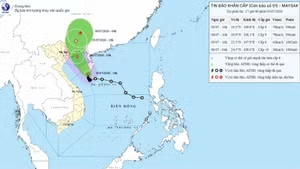
According to the National Centre for Hydro-Meteorological Forecasting (NCHMF) as of 4:00 am on July 23, the storm's centre was located at about 21.1 degrees north latitude and 115.2 degrees east longitude on the coastal area of Quang Ninh-Hai Phong, with strongest winds near the centre at level 8- 9 (62-88 kilometres per hour) and shock at level 11. The storm is moving northwest at 10km per hour.
By 4:00 pm today, the storm's centre will be located at about 21.6 degrees north latitude and 106.8 degrees east longitude, in the Northeastern region, with strongest winds near the centre at level 6 and shock at level 8. The storm will move northwest at 5-10km per hour.
By 4 am on July 24, the storm will be moving west-northwest at 10km per hour. The strongest winds near the centre of the storm will decrease to below level 6 as it weakens into a low pressure area in the northern mountainous area.
Due to the influence of storm No. 2, the waters of the Gulf of Tonkin, including the islands of Bach Long Vi and Co To, are experiencing strong winds of level 6-7, with strongest winds near the centre at level 8-9 and shock at level 11.
On the mainland, the Quang Ninh-Hai Phong area has strong winds of level 6-7, with strongest winds near the centre at level 8 and shock at level 10.
The Lang Son, Bac Giang, Thai Binh areas have strong winds at level 5, with some places at level 6, and shock at level 7.
Warning: The waters of the Gulf of Tonkin (including the islands of Bach Long Vi and Co To) have wave heights of 2-4m, while the coastal waters of Quang Ninh-Hai Phong have waves 2-3m high.
On the afternoon of July 23, coastal provinces from Quang Ninh to Nam Dinh had high tides, with the water level at Hon Dau at 3.8-4m and Cua Ong at 4.6-4.8m, thus slowing down the flood drainage process on rivers and causing flooding in low-lying coastal and riverside areas.