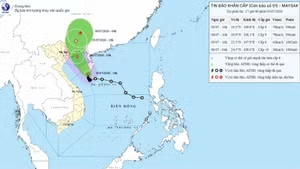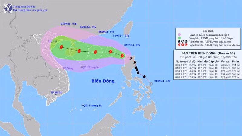
At 7:00 a.m. on September 3, its eye was at approximately 18.4 degrees north latitude and 119.8 degrees east longitude, with the strongest wind near its centre at level 8 (62-74 km per hour), with gusts reaching up to level 11. The typhoon is moving west-northwest at a speed of about 20-25km per hour.
Over the next 24 hours, Yagi is expected to move west-northwest at approximately 10 km per hour, entering the East Sea and intensifying further.
By 7 a.m. on September 4, the storm's centre is projected to be about 740 km east of Hainan Island, China, with winds strengthening to levels 9-10 and gusts at level 12.
In the subsequent 24 to 48 hours, the storm is expected to shift westward at about 10 km per hour, continuing its trajectory into the East Sea and potentially gaining more strength.
By 7 a.m. on September 5, Yagi is forecasted to be approximately 400 km east of Hainan Island, with winds reaching levels 11-12 and gusts at level 14.
The storm is expected to maintain a westward course over the next 48 to 72 hours, with further intensification likely.
By 7 a.m. on September 6, Yagi’s centre is anticipated to be over the eastern waters of Hainan Island, with winds reaching level 13 and gusts up to level 16.
Over the following 72 to 120 hours, Yagi is expected to continue moving west-northwest at 10-15 km per hour, with the potential for further strengthening.
Starting from September 3, the northeastern waters of the North East Sea will experience increasingly strong air currents, reaching level 6, with winds near the storm's centre at levels 8-9 and gusts above levels 11-12, leading to rough seas.
The meteorological agency has issued a warning that from September 4-6, Typhoon Yagi could reach very strong levels in the northeastern part of the East Sea, with maximum winds potentially reaching levels 12-13 and gusts at level 16 near the storm's centre.
For the next 24 hours, the eastern waters of the North East Sea will see waves near the storm's centre reaching 3-5 metres, possibly increasing to 5-7 metres later. The sea will be extremely rough and highly dangerous for vessels.