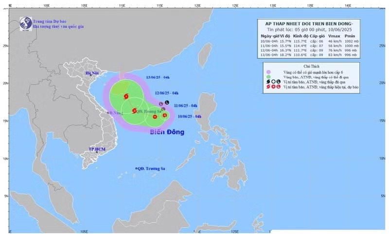
As of 13:00 on June 10, the tropical depression was located about 360km east-southeast of the Hoang Sa (Paracel) Islands, with maximum winds of level 6–7, gusting to level 9. It has been moving slowly west-northwest.
Nguyen Van Huong, Head of the Weather Forecasting Division at the National Centre for Hydro-Meteorological Forecasting, noted favourable conditions for its strengthening, including high sea surface temperatures.
By June 11, the depression is expected to become Storm No. 1 in the East Sea and also the first storm in the Northwest Pacific for the 2025 typhoon season. By 13:00 tomorrow, its centre is forecast to be just east of the Paracel Islands, with wind speeds of level 8, gusting to level 10.
The storm will move west-northwest at about 10km/h and strengthen further. By 13:00 on June 12, it will be northwest of the Paracel Islands, with maximum sustained winds at level 9, gusting to level 11. Over the following 24 hours, it will shift direction to north-northwest, approach Hainan Island, and continue to intensify.
According to Nguyen Van Huong, the storm's wide cloud circulation spans most of the northern and central East Sea, including areas from Quang Tri to Quang Ngai, with winds expected to reach level 9.
The northern and central East Sea will experience strong winds (up to level 8, gusting level 11), heavy rain, and waves 2–4m high. The southern East Sea will also see strong south-westerly winds and rough seas. Coastal areas from Hue to Phu Yen have already experienced scattered rainfall.