At present, the coastal area of Hai Phong City is identified as one of the 10 regions most severely affected by climate change in the Asia-Pacific. Activities such as construction, mineral extraction, aquaculture, and the development of coastal industrial zones have led to the deterioration of the quality of coastal and island ecosystems, including mangrove forests, coral reefs, and seagrass beds. Meanwhile, the city's central objective is to achieve rapid and sustainable socio-economic development associated with a green economic model, ensuring harmony between economic development, environmental protection, and ecosystem conservation.
To obtain essential information and data as a basis for accurately assessing ecosystem changes and the effectiveness of management efforts, a variety of methods have been applied, including periodic on-site monitoring and monitoring using remote sensing data.
However, during implementation, these approaches have revealed numerous limitations and shortcomings, including the need for substantial human and material resources as well as considerable time requirements and financial costs. Specifically, high-resolution commercial satellite imagery is often unavailable, while most satellite images are optical and therefore heavily dependent on weather conditions. Meanwhile, data collected by manned aircraft are generally expensive because of the high operational costs involved.
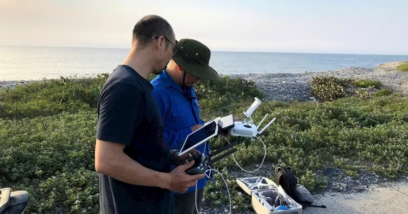
Responding to practical needs, and in order to improve the effectiveness of monitoring and assessing ecosystems — particularly coastal and island ecosystems — Dr Nguyen Van Thao of the Hai Phong Branch of the Institute of Oceanography (Institute of Oceanography, Vietnam Academy of Science and Technology) is leading a project titled "Research on the Application of Small Civilian Unmanned Aerial Vehicles for Assessing the Status of Coastal and Island Ecosystems in Hai Phong."
This is a municipal-level science and technology project of Hai Phong, implemented with the objective of developing an effective operational procedure for using small civilian UAVs to assess the status of coastal and island ecosystems.
The study focuses on the Bang La mangrove ecosystem (Nam Do Son Ward) and the coral reefs around Bach Long Vi Island (Bach Long Vi Special Administrative Area). These locations are regarded as representative sites of the city, containing the most extensive mangrove vegetation and coral reef coverage.
According to Dr Nguyen Van Thao, in monitoring and assessing the city's coastal ecosystems, UAVs are genuinely valuable tools for collecting data and surveying characteristic ecosystems such as mangrove forests and coral reefs. By contrast, traditional methods require selected ecosystems or survey areas to be investigated manually along transects and cross-sections for field sampling, measurement, and subsequent laboratory analysis.
The field survey results are then combined with satellite image interpretation to produce assessments for the entire study area. Under this method, the results often fail to achieve the desired level of accuracy because of the limited spatial resolution of satellite imagery, the small number of survey stations, and the mismatch in timing between satellite image acquisition and field surveys.
Meanwhile, experts believe that deploying small UAVs equipped with multispectral cameras for environmental and coastal ecosystem monitoring enables highly accurate assessments at lower cost while providing much greater precision in determining the timing and location of image acquisition compared with traditional methods.
In addition, navigation technologies using global satellite positioning systems such as GPS, Galileo, and GLONASS enable UAVs to operate under various flight modes and across different terrains to conduct periodic monitoring and capture high-quality images or videos of ecosystems.
For coral reef ecosystems in particular, surveys and monitoring are extremely challenging because of limited underwater visibility and the difficulty of distinguishing between objects with similar spectral characteristics. In such cases, data collected by UAVs can be used to differentiate corals, seaweeds, and other features, thereby enabling relevant authorities to promptly detect adverse changes in distribution area, coverage, species composition, water quality, and sediment conditions, and to implement appropriate measures to protect coastal and island ecosystems. These advantages demonstrate the considerable potential for the widespread application of UAVs in monitoring coastal and island ecosystems across many parts of Viet Nam.
Based on survey results from the Bang La mangrove forest and the shallow waters surrounding Bach Long Vi Island, Dr Hoang Ngoc Tuan, the chairman of the advisory council responsible for evaluating and accepting the results of the municipal science and technology project, stated that small civilian UAVs equipped with multispectral cameras are capable of providing highly detailed data that effectively support the assessment of the current status and monitoring of changes in coastal ecosystems.
Using imagery collected at low altitudes, scientists have developed a survey and image-processing workflow and completed 1:5,000-scale distribution maps of mangrove forests and coral reefs. These results provide a basis for management authorities to monitor changes in the area, coverage, and distribution status of each ecosystem, thereby enabling the timely identification of areas showing signs of degradation. The procedures and data generated have been transferred to the Management Board of the Bach Long Vi Marine Protected Area to support practical management and monitoring, and they may also be further expanded for wider application.
The application of small civilian UAVs equipped with multispectral cameras has demonstrated significant advantages in terms of accuracy, cost-effectiveness and operational flexibility compared with traditional survey methods. This provides a foundation for further refining and expanding the technology for environmental monitoring, biodiversity conservation, and the sustainable management of marine and island resources.