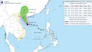
As of 11 am on July 19, the typhoon had reached Category 9, an increase of one level over the past 24 hours, and was located approximately 1,000 kilometre east of the Leizhou Peninsula (China). With an average speed of about 20 kilometres per hour, the typhoon is expected to intensify, reaching Category 12–13, with gusts of Category 14–15 as it moves toward the eastern part of the Leizhou Peninsula. It is forecast to gradually weaken upon entering the Gulf of Tonkin, with wind intensity expected to drop to Category 8–10.
Notably, Lam emphasised that Wipha is a strong and fast-moving typhoon, with heavy rain clouds and strong winds concentrated to the west and south. Therefore, from July 20–21, while the storm is still offshore in the Gulf of Tonkin, thunderstorms are likely to develop in coastal and offshore areas of northern Viet Nam.
According to the National Centre for Hydrometeorological Forecasting, in the next 24 hours, the greatest risks posed by the storm include strong winds and high waves in the northern and central parts of the East Sea, particularly in the northern area of the Hoang Sa (Paracel) Archipelago, where wind speeds may reach Category 10–12, with gusts up to Category 15, and wave heights of 4 to 6 metres are expected.
From July 20–21, areas such as Bach Long Vi, Co To, and Cat Hai may experience significant impacts from strong winds and heavy rain. By the early morning and throughout July 22, coastal areas from Quang Ninh to Thanh Hoa will start to be directly affected by the storm, with winds reaching Category 7–9 and waves of 3 to 5 metres. Large waves combined with high tides could lead to flooding in low-lying coastal areas of Quang Ninh and Hai Phong from the afternoon of July 21 through July 23.
On land, the storm’s area of influence will span across the entire northeastern region, parts of the northwestern region, and the north-central region. Provinces such as Quang Ninh, Hai Phong, Hung Yen, Ninh Binh, and Thanh Hoa are expected to be among the most directly and severely affected. Widespread heavy rainfall is forecast for the northern region and from Thanh Hoa to Ha Tinh from July 21–24, with some areas experiencing localised downpours exceeding 150 mm in just three hours.
Of particular concern, from July 21 to 24, rivers in northern Viet Nam, Thanh Hoa, and Nghe An may experience flood surges with water levels rising 3 to 6 metres. There is a high risk of flooding in low-lying riverbank areas, urban zones, and residential communities, as well as flash floods and landslides in mountainous regions of northern Viet Nam, Thanh Hoa, and Nghe An.
The National Centre for Hydrometeorological Forecasting advises local authorities, agencies, and residents to closely monitor storm developments and proactively implement response measures to safeguard lives and property of the people.