In response to these challenges, the application of remote sensing imagery and artificial intelligence is unlocking new approaches, facilitating a shift from a reactive response to drought towards more proactive, scientific, and timely drought risk management.
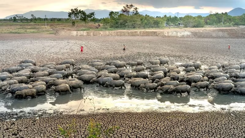
Severe droughts during 2014–2016 and 2019–2020, together with forecasts of the impact of El Niño in 2026–2027, demonstrate that Viet Nam is among the countries acutely affected by water shortages, falling water levels in rivers and reservoirs, and saltwater intrusion.
In addition to imposing hardships on daily life, drought has a profound impact on agricultural production, particularly in areas frequently affected by water shortages such as the South Central Coast, Central Highlands, and Mekong Delta.
Depending on its characteristics and severity, drought is categorised as meteorological, hydrological, agricultural, or socio-economic drought. Hydrological and agricultural drought, in particular, often have direct impacts on reservoir regulation, crop production, and people's livelihoods.
According to Hoang Duc Cuong, Deputy Director of the Meteorological and Hydrological Administration, the actual impact depends not only on the intensity of El Niño but also on its duration, the state of water resources at the beginning of the dry season, reservoir storage and regulation capacity, river basin flows, and the response capacity of each area. Therefore, forecast information must be systematically updated to support the early development of response plans.
The current imperative is to make a decisive shift from “disaster management” to “disaster risk management” through monitoring, forecasting, warning, and decision-making support. Based on assessments of water availability, specialised agencies can calculate appropriate planting areas, adjust crop calendars, select suitable crop structures, and develop water supply and reservoir operation plans. This establishes a critical foundation for local authorities to proactively direct agricultural production and minimise losses caused by drought and water shortages.
A prominent hallmark of the current approach is the combination of multiple data sources and technologies, ranging from global climate models, regional climate models, and global rainfall data to remote sensing imagery from international organisations such as ESA, NASA, JAXA, and NOAA, as well as indicators used to monitor and assess drought, including SPI, PDSI, and NDVI.
A pivotal instrument is the Regional Hydrologic Extremes Assessment System (RHEAS), developed by NASA's Jet Propulsion Laboratory (JPL) in the US and transferred to the Viet Nam Academy for Water Resources by the Asian Disaster Preparedness Centre. The platform provides access to various drought-related indicators and parameters, including composite drought indices, standardised precipitation, and streamflow; soil moisture deficits, drought severity, and root-zone moisture; surface runoff and groundwater flow; potential evapotranspiration, rainfall, relative humidity, and surface temperature.
These data sources facilitate the development of drought maps, monthly drought forecasts, water resource inventory and forecasting systems, satellite-based reservoir monitoring systems, and tools to support reservoir operations. Instead of relying mainly on manual monitoring or periodic reports, management agencies can monitor changes in water resources in near real time, enabling them to expedite decision-making and respond more closely to actual conditions.
For agricultural production, decision-support systems can deliver intelligence regarding water availability, crop yield forecasts, areas suitable for cultivation, and drought risk levels in individual areas. In reservoir management, satellite imagery can facilitate the monitoring of changes in storage capacity and water levels, supporting assessments of the ability to supply water to downstream areas. When combined with weather forecasting models, short-range, and seasonal forecasts, these systems can provide more flexible operating scenarios, ensuring water supplies for domestic use and production while helping reduce risks under extreme weather conditions.
Despite their considerable potential, digital technology-based drought monitoring and forecasting continue to confront numerous challenges. Many tools, systems, and devices have been developed separately and have yet to be integrated in a coordinated manner, with most still at the pilot stage.
Databases serving water resource management, disaster management, agricultural production, and reservoir operations remain fragmented, and no sufficiently robust shared platform has yet been established. When applied at regional or national scale, the volume of real-time data exchanged will be enormous, while network infrastructure and the capacity for storing, processing, and analysing big data remain constrained. In addition, human resources in information technology, network administration, data analysis, and the operation of forecasting models are still insufficient to fully meet practical requirements.
In light of this situation, Associate Professor and Doctor Ha Hai Duong of the Viet Nam Academy for Water Resources emphasised the necessity of developing decision-support systems for water resource inventories and crop yield forecasting in major river basins; establish databases on available water resources to support community water supply; and develop databases on orientations for crop restructuring tailored to water resource conditions.
At the same time, databases and digital maps on water security risks and dam and reservoir safety must be systematically formulated, while disaster risk mapping systems and early warning systems must be rigorously refined. Priority areas include the Mekong Delta, South Central Coast, Central Highlands, and northern mountainous areas — regions that are highly vulnerable to drought, water shortages, saltwater intrusion, and climate variability.
In the long term, water resource monitoring and forecasting will not only facilitate drought response efforts but also provide an important foundation for water resource management, agricultural production planning, dam and reservoir safety, and climate change adaptation.